National Register of Historic Places listings in Anchorage, Alaska

This is a list of the National Register of Historic Places listings in Anchorage, Alaska.
This is intended to be a complete list of the properties and districts on the National Register of Historic Places in Anchorage, Alaska, United States. The locations of National Register properties and districts for which the latitude and longitude coordinates are included below, may be seen in an online map.[1]
There are currently 37 properties and districts listed on the National Register in the city. One additional property was previously listed but has since been removed from the register.
Current listings
This National Park Service list is complete through NPS recent listings posted August 23, 2024.[2]
Map all coordinates using OpenStreetMap
Download coordinates as:
- KML
- GPX (all coordinates)
- GPX (primary coordinates)
- GPX (secondary coordinates)
| [3] | Name on the Register[4] | Image | Date listed[5] | Location | City or town | Description |
|---|---|---|---|---|---|---|
| 1 | A.E.C. Cottage No. 23 |  | June 11, 1990 (#90000825) | 618 Christensen Drive 61°13′12″N 149°53′41″W / 61.220083°N 149.894611°W / 61.220083; -149.894611 (A.E.C. Cottage No. 23) | Anchorage | |
| 2 | Alaska Engineering Commission Cottage No. 25 |  | February 16, 1996 (#96000094) | 645 West Third Avenue 61°13′11″N 149°53′43″W / 61.21973°N 149.89523°W / 61.21973; -149.89523 (Alaska Engineering Commission Cottage No. 25) | Anchorage | |
| 3 | Mike Alex Cabin | Upload image | September 8, 1982 (#82002071) | Off Alaska Route 1 61°27′37″N 149°21′38″W / 61.46016°N 149.36061°W / 61.46016; -149.36061 (Mike Alex Cabin) | Eklutna | |
| 4 | Anchorage Cemetery |  | April 26, 1993 (#93000320) | 535 East 9th Avenue 61°12′54″N 149°52′34″W / 61.21511°N 149.87601°W / 61.21511; -149.87601 (Anchorage Cemetery) | Anchorage | |
| 5 | Anchorage City Hall | 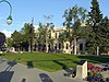 | December 2, 1980 (#80000745) | 524 West Fourth Avenue 61°13′06″N 149°53′33″W / 61.21822°N 149.89248°W / 61.21822; -149.89248 (Anchorage City Hall) | Anchorage | The city's 1936 city hall. |
| 6 | Anchorage Depot | 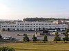 | August 27, 1999 (#99001027) | 411 West First Avenue 61°13′18″N 149°53′26″W / 61.22168°N 149.89047°W / 61.22168; -149.89047 (Anchorage Depot) | Anchorage | |
| 7 | Anchorage Hotel Annex |  | April 15, 1999 (#99000443) | 330 E Street 61°13′08″N 149°53′30″W / 61.21884°N 149.89175°W / 61.21884; -149.89175 (Anchorage Hotel Annex) | Anchorage | |
| 8 | Oscar Anderson House |  | June 13, 1978 (#78000514) | 420 M Street 61°13′07″N 149°54′22″W / 61.21856°N 149.90601°W / 61.21856; -149.90601 (Oscar Anderson House) | Anchorage | |
| 9 | Beluga Point Site | 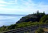 | March 30, 1978 (#78000515) | Address restricted[6] | Anchorage | |
| 10 | Block 13 Army Housing Association Historic District | Upload image | December 3, 2018 (#100003171) | E 10th & 11th Aves., Barrow & Cordova Sts. 61°12′44″N 149°52′49″W / 61.2121°N 149.8803°W / 61.2121; -149.8803 (Block 13 Army Housing Association Historic District) | Anchorage | |
| 11 | Campus Center |  | June 22, 1979 (#79000409) | 4101 University Drive 61°11′27″N 149°48′12″W / 61.190972°N 149.803333°W / 61.190972; -149.803333 (Campus Center) | Anchorage | Also known as Atwood Campus Center of Alaska Pacific University. |
| 12 | Civil Works Residential Dwellings | 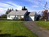 | July 21, 2004 (#04000717) | 786 and 800 Delaney Street 61°13′40″N 149°53′20″W / 61.227722°N 149.888972°W / 61.227722; -149.888972 (Civil Works Residential Dwellings) | Anchorage | |
| 13 | Crow Creek Consolidated Gold Mining Company | 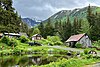 | September 13, 1978 (#78000517) | Crow Creek Road 61°00′01″N 149°04′57″W / 61.00037°N 149.08258°W / 61.00037; -149.08258 (Crow Creek Consolidated Gold Mining Company) | Girdwood | |
| 14 | Leopold David House | 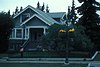 | July 24, 1986 (#86001900) | 605 West Second Avenue 61°13′15″N 149°53′38″W / 61.22077°N 149.89388°W / 61.22077; -149.89388 (Leopold David House) | Anchorage | |
| 15 | Eklutna Power Plant |  | June 20, 1980 (#80000746) | Northeast of central Anchorage 61°27′30″N 149°20′24″W / 61.45847°N 149.33992°W / 61.45847; -149.33992 (Eklutna Power Plant) | Anchorage | Anchorage's first hydroelectric plant, built 1929. Currently known as the Old Eklutna Power Plant as a new dam and power plant has been built elsewhere in 1955. |
| 16 | Federal Building-U.S. Courthouse |  | June 23, 1978 (#78000516) | 605 West Fourth Avenue 61°13′08″N 149°53′40″W / 61.21885°N 149.8945°W / 61.21885; -149.8945 (Federal Building-U.S. Courthouse) | Anchorage | |
| 17 | Fort Richardson National Cemetery | 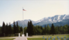 | March 7, 2012 (#12000056) | Building 58-512, Davis Highway 61°16′31″N 149°39′37″W / 61.2754°N 149.66028°W / 61.2754; -149.66028 (Fort Richardson National Cemetery) | Fort Richardson | |
| 18 | Fourth Avenue Theatre | 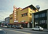 | October 5, 1982 (#82001620) | 630 West Fourth Avenue 61°13′06″N 149°53′40″W / 61.21828°N 149.89449°W / 61.21828; -149.89449 (Fourth Avenue Theatre) | Anchorage | |
| 19 | Oscar Gill House |  | February 2, 2001 (#01000022) | 1344 West Tenth Avenue 61°12′45″N 149°54′34″W / 61.21245°N 149.90953°W / 61.21245; -149.90953 (Oscar Gill House) | Anchorage | Originally built in the town of Knik in 1913, moved to 918 West Tenth Avenue in 1916 and to its current location during the 1980s. |
| 20 | Government Hill Federal Housing Historic District | | January 14, 2015 (#14001147) | W. Harvard, Delaney & Brown Sts. 61°13′43″N 149°53′11″W / 61.22856°N 149.88626°W / 61.22856; -149.88626 (Government Hill Federal Housing Historic District) | Anchorage | |
| 21 | Greater Friendship Baptist Church | 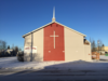 | June 21, 2019 (#100003109) | 903 E 13th Ave. 61°12′36″N 149°51′59″W / 61.2099°N 149.8665°W / 61.2099; -149.8665 (Greater Friendship Baptist Church) | Anchorage | |
| 22 | Indian Valley Mine | Upload image | October 25, 1989 (#89001762) | Address restricted[6] | Indian | |
| 23 | KENI Radio Building | 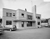 | April 18, 1988 (#88000380) | 1777 Forest Park Drive 61°12′19″N 149°55′31″W / 61.20541°N 149.92534°W / 61.20541; -149.92534 (KENI Radio Building) | Anchorage | |
| 24 | Kimball's Store | 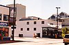 | July 24, 1986 (#86001901) | 500 and 504 West Fifth Avenue 61°13′03″N 149°53′30″W / 61.21738°N 149.89173°W / 61.21738; -149.89173 (Kimball's Store) | Anchorage | |
| 25 | Kulis Hangar 1, Building 3 | Upload image | March 4, 2019 (#100003385) | 5005 Raspberry Rd. 61°09′33″N 149°58′21″W / 61.1591°N 149.9725°W / 61.1591; -149.9725 (Kulis Hangar 1, Building 3) | Anchorage | |
| 26 | Loussac-Sogn Building | 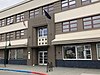 | May 20, 1998 (#98000567) | 429 D Street 61°13′04″N 149°53′20″W / 61.21786°N 149.88893°W / 61.21786; -149.88893 (Loussac-Sogn Building) | Anchorage | |
| 27 | McKinley Tower Apartments |  | September 12, 2008 (#08000882) | 337 East Fourth Avenue 61°13′08″N 149°52′39″W / 61.21883°N 149.87748°W / 61.21883; -149.87748 (McKinley Tower Apartments) | Anchorage | |
| 28 | Mt. Alyeska Roundhouse |  | November 5, 2003 (#02000562) | Approximately 2 miles (3.2 km) west of Alyeska 60°57′42″N 149°04′50″W / 60.96165°N 149.08049°W / 60.96165; -149.08049 (Mt. Alyeska Roundhouse) | Girdwood | Mountaintop ski lodge and museum, an octagonal building, part of Alyeska Resort. |
| 29 | Old St. Nicholas Russian Orthodox Church | 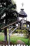 | March 24, 1972 (#72000189) | Mile 1/2, Eklutna Village Road 61°27′38″N 149°21′42″W / 61.46069°N 149.36162°W / 61.46069; -149.36162 (Old St. Nicholas Russian Orthodox Church) | Eklutna | |
| 30 | Pilgrim 100B Aircraft |  | August 7, 1986 (#86002230) | Alaska Aviation Heritage Museum 61°10′45″N 149°58′23″W / 61.17907°N 149.97303°W / 61.17907; -149.97303 (Pilgrim 100B Aircraft) | Anchorage | Originally listed at Dillingham Airport, this aircraft is now in the collection of the Alaska Aviation Heritage Museum. |
| 31 | Pioneer School House |  | December 3, 1980 (#80000747) | 437 East 3rd Avenue 61°13′12″N 149°52′32″W / 61.21992°N 149.87556°W / 61.21992; -149.87556 (Pioneer School House) | Anchorage | |
| 32 | Potter Section House |  | December 6, 1985 (#85003113) | Off Alaska Route 1 61°03′07″N 149°47′49″W / 61.05191°N 149.79686°W / 61.05191; -149.79686 (Potter Section House) | Anchorage | |
| 33 | Site Summit | 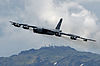 | July 11, 1996 (#96000691) | Off Arctic Valley Road, 12.5 miles (20.1 km) east of central Anchorage 61°15′07″N 149°32′23″W / 61.25205°N 149.53985°W / 61.25205; -149.53985 (Site Summit) | Anchorage | The historical 244 acres (99 ha) area covers the Battery Area to the north and the Launch Area to the south.[4] |
| 34 | Spring Creek Lodge | 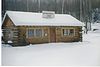 | September 9, 2001 (#01000938) | 18939 Old Glenn Highway 61°23′28″N 149°28′03″W / 61.39123°N 149.46753°W / 61.39123; -149.46753 (Spring Creek Lodge) | Chugiak | |
| 35 | Temnac P-38G Lightning | 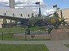 | June 26, 1979 (#79000406) | McCloud Memorial Park, Elmendorf Air Force Base[7] 61°14′54″N 149°48′07″W / 61.24832°N 149.80185°W / 61.24832; -149.80185 (Temnac P-38G Lightning) | Anchorage | A P-38G grounded on Attu Island during World War II, it was recovered in the 1990s, restored, and moved to its current location in April 2000.[7] |
| 36 | Wendler Building | 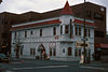 | June 24, 1988 (#88000730) | 400 D Street 61°13′06″N 149°53′23″W / 61.21828°N 149.88971°W / 61.21828; -149.88971 (Wendler Building) | Anchorage | Originally located at intersection of 4th Avenue and I Street, the building was moved to its current location during the 1980s. |
| 37 | The Wireless Station | 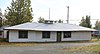 | December 1, 2015 (#15000843) | 124, 132 and 140 East Manor Avenue 61°13′45″N 149°52′53″W / 61.2293°N 149.88143°W / 61.2293; -149.88143 (The Wireless Station) | Anchorage |
Former listing
| [3] | Name on the Register | Image | Date listed | Date removed | Location | City or town | Description |
|---|---|---|---|---|---|---|---|
| 1 | Lathrop Building | Upload image | April 22, 1984 (#84000629) | October 19, 1987 | 801 W. 4th Ave. 61°13′09″N 149°53′36″W / 61.2192°N 149.8933°W / 61.2192; -149.8933 (Lathrop Building) | Anchorage |
See also
- List of National Historic Landmarks in Alaska
- National Register of Historic Places listings in Alaska
References
Wikimedia Commons has media related to National Register of Historic Places in Anchorage, Alaska.
- ^ The latitude and longitude information provided in this table was derived originally from the National Register Information System, which has been found to be fairly accurate for about 99% of listings. Some locations in this table may have been corrected to current GPS standards.
- ^ National Park Service, United States Department of the Interior, "National Register of Historic Places: Weekly List Actions", retrieved August 23, 2024.
- ^ a b Numbers represent an alphabetical ordering by significant words. Various colorings, defined here, differentiate National Historic Landmarks and historic districts from other NRHP buildings, structures, sites or objects.
- ^ a b "National Register Information System". National Register of Historic Places. National Park Service. April 24, 2008.
- ^ The eight-digit number below each date is the number assigned to each location in the National Register Information System database, which can be viewed by clicking the number.
- ^ a b Federal and state laws and practices restrict general public access to information regarding the specific location of this resource. In some cases, this is to protect archeological sites from vandalism, while in other cases it is restricted at the request of the owner. See: Knoerl, John; Miller, Diane; Shrimpton, Rebecca H. (1990), Guidelines for Restricting Information about Historic and Prehistoric Resources, National Register Bulletin, National Park Service, U.S. Department of the Interior, OCLC 20706997.
- ^ a b Fisher, S/Sgt. Jim, "A Fitting Tribute", Airman, Air Force News Agency, San Antonio, Texas, September 2000, Volume XLIV, Number 9, pages 38-41.
- v
- t
- e
- List of U.S. National Historic Landmarks by state:
- Alabama
- Alaska
- Arizona
- Arkansas
- California
- Colorado
- Connecticut
- Delaware
- Florida
- Georgia
- Hawaii
- Idaho
- Illinois
- Indiana
- Iowa
- Kansas
- Kentucky
- Louisiana
- Maine
- Maryland
- Massachusetts
- Michigan
- Minnesota
- Mississippi
- Missouri
- Montana
- Nebraska
- Nevada
- New Hampshire
- New Jersey
- New Mexico
- New York
- North Carolina
- North Dakota
- Ohio
- Oklahoma
- Oregon
- Pennsylvania
- Rhode Island
- South Carolina
- South Dakota
- Tennessee
- Texas
- Utah
- Vermont
- Virginia
- Washington
- West Virginia
- Wisconsin
- Wyoming
 National Register of Historic Places portal
 Category


| |||
|---|---|---|---|
Boroughs |  | ||
Census areas | |||
There are no sites listed on the National Register of Historic Places in Kusilvak Census Area. | |||


