National Register of Historic Places listings in Kenai Peninsula Borough, Alaska

This is a list of the National Register of Historic Places listings in Kenai Peninsula Borough, Alaska.
This is intended to be a complete list of the properties and districts on the National Register of Historic Places in Kenai Peninsula Borough, Alaska, United States. The locations of National Register properties and districts for which the latitude and longitude coordinates are included below, may be seen in an online map.[1]
There are 38 properties and districts listed on the National Register in the borough, including 2 National Historic Landmarks.
This National Park Service list is complete through NPS recent listings posted August 23, 2024.[2]
Map all coordinates using OpenStreetMap
Download coordinates as:
- KML
- GPX (all coordinates)
- GPX (primary coordinates)
- GPX (secondary coordinates)
Current listings
| [3] | Name on the Register[4] | Image | Date listed[5] | Location | City or town | Description |
|---|---|---|---|---|---|---|
| 1 | Alaska Central Railroad: Tunnel No. 1 |  | November 28, 1977 (#77001576) | About 40 miles (64 km) north of Seward, in Placer River valley 60°39′14″N 149°03′28″W / 60.65375°N 149.0578°W / 60.65375; -149.0578 (Alaska Central Railroad: Tunnel No. 1) | Seward | |
| 2 | Alaska Nellie's Homestead |  | April 3, 1975 (#75002159) | Mile 23 on the Seward Highway 60°24′04″N 149°21′53″W / 60.40117°N 149.36467°W / 60.40117; -149.36467 (Alaska Nellie's Homestead) | Lawing | |
| 3 | Ballaine House |  | July 12, 1978 (#78003429) | 437 3rd Avenue 60°06′23″N 149°26′33″W / 60.10638°N 149.44261°W / 60.10638; -149.44261 (Ballaine House) | Seward | |
| 4 | Andrew Berg Cabin | 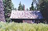 | April 21, 2000 (#00000385) | About 30 miles (48 km) southeast of Soldotna, on Tustumena Lake 60°07′03″N 150°37′48″W / 60.11747°N 150.62996°W / 60.11747; -150.62996 (Andrew Berg Cabin) | Soldotna | |
| 5 | Brown & Hawkins Store | 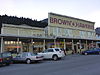 | June 23, 1988 (#88000710) | 205, 207, and 209 4th Avenue 60°06′05″N 149°26′27″W / 60.10141°N 149.44096°W / 60.10141; -149.44096 (Brown & Hawkins Store) | Seward | |
| 6 | Chugachik Island Site | Upload image | August 19, 1976 (#76002279) | Address restricted[6] | Kachemak Bay | |
| 7 | Church of the Assumption of the Virgin Mary | 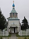 | May 10, 1970 (#70000898) | Corner of Mission Street and Overland Street 60°33′11″N 151°16′03″W / 60.55295°N 151.2675°W / 60.55295; -151.2675 (Church of the Assumption of the Virgin Mary) | Kenai | |
| 8 | Clam Cove Pictograph Site | 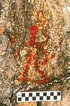 | December 22, 2017 (#100001904) | Address restricted | Port Alsworth | |
| 9 | Coal Village Site | Upload image | November 21, 1978 (#78003424) | Coal Cove, about 4 miles (6.4 km) northwest of Port Graham 59°23′54″N 151°54′06″W / 59.39839°N 151.90165°W / 59.39839; -151.90165 (Coal Village Site) | Port Graham | |
| 10 | Cooper Landing Historic District | Upload image | August 21, 1986 (#86001475) | Mile 48.7 of Sterling Highway 60°29′21″N 149°49′57″W / 60.48917°N 149.83256°W / 60.48917; -149.83256 (Cooper Landing Historic District) | Cooper Landing | |
| 11 | Cooper Landing Post Office |  | May 23, 1978 (#78003425) | Sterling Highway 60°29′25″N 149°49′57″W / 60.490278°N 149.8325°W / 60.490278; -149.8325 (Cooper Landing Post Office) | Cooper Landing | |
| 12 | Diversion Tunnel |  | November 23, 1977 (#77001577) | At end of Lowell Canyon Road, on Lowell Creek. 60°06′11″N 149°27′09″W / 60.10301°N 149.45254°W / 60.10301; -149.45254 (Diversion Tunnel) | Seward | US Corps of Engineers tunnel that diverts Lowell Creek under Bear Mountain |
| 13 | Fort McGilvray Historic District | Upload image | December 27, 2022 (#100007802) | Caines Head State Recreation Area 59°59′13″N 149°23′25″W / 59.9870°N 149.3902°W / 59.9870; -149.3902 (Fort McGilvray Historic District) | Seward vicinity | |
| 14 | Government Cable Office |  | January 4, 1980 (#80004574) | 218 6th Avenue 60°06′07″N 149°26′15″W / 60.10195°N 149.43762°W / 60.10195; -149.43762 (Government Cable Office) | Seward | |
| 15 | Hirshey Mine | Upload image | September 13, 1978 (#78003419) | About 12 miles (19 km) southeast of Hope, on Palmer Creek Road 60°47′33″N 149°31′54″W / 60.79262°N 149.53153°W / 60.79262; -149.53153 (Hirshey Mine) | Hope | |
| 16 | Hoben Park |  | June 21, 2006 (#06000515) | 401 Railway Avenue 60°06′01″N 149°26′23″W / 60.10023°N 149.43959°W / 60.10023; -149.43959 (Hoben Park) | Seward | |
| 17 | Victor Holm Cabin | Upload image | April 13, 1977 (#77001573) | About 2.5 miles (4.0 km) northwest of Kasilof, on Cohoe Road, near the bank of Kasilof River 60°22′08″N 151°18′13″W / 60.36898°N 151.30353°W / 60.36898; -151.30353 (Victor Holm Cabin) | Kenai[a] | 1890 cabin built by pioneering homesteader Victor Holm |
| 18 | Victor Holm Homestead | Upload image | January 17, 2006 (#05000032) | About 2.5 miles (4.0 km) northwest of Kasilof, on Cohoe Road, near the bank of Kasilof River 60°22′09″N 151°18′13″W / 60.36906°N 151.30374°W / 60.36906; -151.30374 (Victor Holm Homestead) | Kasilof[b] | Encompasses entire Victor Holm property, including Victor Holm Cabin and other outbuildings |
| 19 | Holy Transfiguration of Our Lord Chapel |  | May 22, 1978 (#78003426) | Orthodox Avenue, Mile 135 of Sterling Highway 60°03′01″N 151°39′55″W / 60.05025°N 151.66535°W / 60.05025; -151.66535 (Holy Transfiguration of Our Lord Chapel) | Ninilchik | |
| 20 | Hope Historic District |  | April 25, 1972 (#72001583) | Roughly bounded by Main Street, Hope Highway, Fifth Street and the Turnagain Arm 60°55′07″N 149°38′27″W / 60.91873°N 149.64081°W / 60.91873; -149.64081 (Hope Historic District) | Hope | |
| 21 | Harry A. Johnson Trapline Cabin | Upload image | May 5, 2000 (#00000424) | About 15 miles (24 km) southwest of Hope 60°45′21″N 149°56′46″W / 60.75585°N 149.94616°W / 60.75585; -149.94616 (Harry A. Johnson Trapline Cabin) | Hope | |
| 22 | Lauritsen Cabin | Upload image | October 16, 1979 (#79003761) | About 13.5 miles (21.7 km) northwest of Moose Pass, along west bank of Lake Creek 60°40′22″N 149°28′27″W / 60.6729°N 149.4742°W / 60.6729; -149.4742 (Lauritsen Cabin) | Moose Pass | |
| 23 | Jesse Lee Home for Children | Upload image | September 29, 1995 (#95001146) | Benson Drive 60°07′34″N 149°26′47″W / 60.1262°N 149.4464°W / 60.1262; -149.4464 (Jesse Lee Home for Children) | Seward | |
| 24 | Magnetic Island Site | Upload image | March 17, 2015 (#15000071) | Address restricted[6] | Port Alsworth | |
| 25 | Moose River Site | Upload image | December 20, 1978 (#78003427) | Address restricted[6] | Sterling | |
| 26 | St. Nicholas Chapel |  | June 6, 1980 (#80004588) | Church Street 59°26′22″N 151°42′59″W / 59.4394°N 151.7163°W / 59.4394; -151.7163 (St. Nicholas Chapel) | Seldovia | |
| 27 | St. Peter's Episcopal Church | 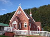 | December 21, 1979 (#79003762) | 239 2nd Avenue 60°06′10″N 149°26′39″W / 60.1027°N 149.4443°W / 60.1027; -149.4443 (St. Peter's Episcopal Church) | Seward | |
| 28 | Sts. Sergius and Herman of Valaam Church |  | June 6, 1980 (#80004587)[c] | Nicholas Street 59°21′18″N 151°55′16″W / 59.3551°N 151.9211°W / 59.3551; -151.9211 (Sts. Sergius and Herman of Valaam Church) | Nanwalek | 1930 Russian Orthodox Church (next to more recent one). |
| 29 | Selenie Lagoon Archeological Site | Upload image | October 16, 1974 (#74002321) | Address restricted[6] | Port Graham | |
| 30 | Seward Depot |  | July 16, 1987 (#87000652) | 501 Railway Avenue 60°06′03″N 149°26′20″W / 60.1007°N 149.4389°W / 60.1007; -149.4389 (Seward Depot) | Seward | |
| 31 | Snug Harbor Packing Company |  | September 11, 2023 (#100009319) | Chisik Island 60°06′30″N 152°34′51″W / 60.1084°N 152.5808°W / 60.1084; -152.5808 (Snug Harbor Packing Company) | Tuxnedi Wilderness Area, Alaska Maritime National Wildlife Refuge | |
| 32 | Soldotna Post Office | 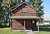 | September 17, 2008 (#08000904) | Corner of East Corral Avenue and Kenai Spur Highway 60°29′34″N 151°04′05″W / 60.4928°N 151.0681°W / 60.4928; -151.0681 (Soldotna Post Office) | Soldotna | |
| 33 | Sunrise City Historic District |  | August 19, 1997 (#97000892) | At the mouth of Sixmile Creek, east of Hope[7] 60°53′20″N 149°25′16″W / 60.8889°N 149.4211°W / 60.8889; -149.4211 (Sunrise City Historic District) | Hope | |
| 34 | Swetman House |  | February 17, 1978 (#78003430) | 325 5th Avenue 60°06′15″N 149°26′21″W / 60.1041°N 149.4393°W / 60.1041; -149.4393 (Swetman House) | Seward | |
| 35 | Thorn-Stingley House | 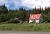 | February 2, 2001 (#01000023) | 1660 East End Road 59°39′23″N 151°30′02″W / 59.6565°N 151.5006°W / 59.6565; -151.5006 (Thorn-Stingley House) | Homer | |
| 36 | Tuxedni Bay Pictograph Site | 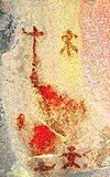 | August 11, 2020 (#100001776) | Address Restricted | Port Alsworth vicinity | |
| 37 | Van Gilder Hotel |  | December 2, 1980 (#80004575) | 307 Adams Street 60°06′11″N 149°26′28″W / 60.1031°N 149.4412°W / 60.1031; -149.4412 (Van Gilder Hotel) | Seward | |
| 38 | Yukon Island Main Site |  | October 15, 1966 (#66000955) | Yukon Island, 9 miles south of Homer[8] 59°31′20″N 151°29′54″W / 59.5222°N 151.4983°W / 59.5222; -151.4983 (Yukon Island Main Site) | Homer |
See also
Wikimedia Commons has media related to National Register of Historic Places in Kenai Peninsula Borough, Alaska.
- List of National Historic Landmarks in Alaska
- National Register of Historic Places listings in Alaska
References
- ^ The latitude and longitude information provided in this table was derived originally from the National Register Information System, which has been found to be fairly accurate for about 99% of listings. Some locations in this table may have been corrected to current GPS standards.
- ^ National Park Service, United States Department of the Interior, "National Register of Historic Places: Weekly List Actions", retrieved August 23, 2024.
- ^ Numbers represent an alphabetical ordering by significant words. Various colorings, defined here, differentiate National Historic Landmarks and historic districts from other NRHP buildings, structures, sites or objects.
- ^ "National Register Information System". National Register of Historic Places. National Park Service. April 24, 2008.
- ^ The eight-digit number below each date is the number assigned to each location in the National Register Information System database, which can be viewed by clicking the number.
- ^ a b c d Federal and state laws and practices restrict general public access to information regarding the specific location of this resource. In some cases, this is to protect archeological sites from vandalism, while in other cases it is restricted at the request of the owner. See: Knoerl, John; Miller, Diane; Shrimpton, Rebecca H. (1990), Guidelines for Restricting Information about Historic and Prehistoric Resources, National Register Bulletin, National Park Service, U.S. Department of the Interior, OCLC 20706997.
- ^ Location derived from its GNIS feature record; the NRIS lists the site as "Address Restricted"
- ^ Location (derived from the GNIS) is for the small island on which the site is located; the NRIS lists the site as "Address Restricted"
Notes
- ^ Even if Cohoe, Alaska is the nearest census designated place, NRHP registration form mention Kenai for Victor Holm Cabin location
- ^ Even if Cohoe, Alaska is the nearest census designated place, NRHP registration form mention Kasilof for Victor Holm Homestead location
- ^ There's an error in NRHP listing for this building. Listing 80004587 attached form and pictures refer to Sts. Sergius and Herman of Valaam Chapel in Ouzinkie. The correct form and pictures for this building are attached to listing 80004581 (form and pictures)
- v
- t
- e
- List of U.S. National Historic Landmarks by state:
- Alabama
- Alaska
- Arizona
- Arkansas
- California
- Colorado
- Connecticut
- Delaware
- Florida
- Georgia
- Hawaii
- Idaho
- Illinois
- Indiana
- Iowa
- Kansas
- Kentucky
- Louisiana
- Maine
- Maryland
- Massachusetts
- Michigan
- Minnesota
- Mississippi
- Missouri
- Montana
- Nebraska
- Nevada
- New Hampshire
- New Jersey
- New Mexico
- New York
- North Carolina
- North Dakota
- Ohio
- Oklahoma
- Oregon
- Pennsylvania
- Rhode Island
- South Carolina
- South Dakota
- Tennessee
- Texas
- Utah
- Vermont
- Virginia
- Washington
- West Virginia
- Wisconsin
- Wyoming
 National Register of Historic Places portal
 Category


| |||
|---|---|---|---|
Boroughs |  | ||
Census areas | |||
There are no sites listed on the National Register of Historic Places in Kusilvak Census Area. | |||
Municipalities and communities of Kenai Peninsula Borough, Alaska, United States | ||
|---|---|---|
Borough seat: Soldotna | ||
| Cities |  | |
| CDPs |
| |
| Unincorporated communities | ||
| Ghost town | ||
| ||


