National Register of Historic Places listings in Hoonah–Angoon Census Area, Alaska

This is a list of the National Register of Historic Places listings in Hoonah–Angoon Census Area, Alaska.
This is intended to be a complete list of the properties and districts on the National Register of Historic Places in Hoonah-Angoon Census Area, Alaska, United States. The locations of National Register properties and districts for which the latitude and longitude coordinates are included below, may be seen in a Google map.[1]
There are 20 properties and districts listed on the National Register in the census area.
This National Park Service list is complete through NPS recent listings posted August 23, 2024.[2]
Map all coordinates using OpenStreetMap
Download coordinates as:
- KML
- GPX (all coordinates)
- GPX (primary coordinates)
- GPX (secondary coordinates)
Current listings
| [3] | Name on the Register[4] | Image | Date listed[5] | Location | City or town | Description |
|---|---|---|---|---|---|---|
| 1 | Alexander Lake Shelter Cabin | 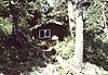 | November 2, 1995 (#95001296) | Eastern end of Lake Alexander, Admiralty Island National Monument 57°39′45″N 134°08′39″W / 57.66237°N 134.1443°W / 57.66237; -134.1443 (Alexander Lake Shelter Cabin) | Angoon | |
| 2 | Beaver Lake Dam | Upload image | November 2, 1995 (#95001295) | Between Beaver Lake and Lake Alexander, Admiralty Island National Monument 57°40′15″N 134°11′31″W / 57.67072°N 134.19203°W / 57.67072; -134.19203 (Beaver Lake Dam) | Angoon | |
| 3 | Big Shaheen Cabin |  | November 2, 1995 (#95001292) | On Hasselborg Lake, Admiralty Island National Monument 57°42′04″N 134°16′42″W / 57.70103°N 134.27821°W / 57.70103; -134.27821 (Big Shaheen Cabin) | Angoon | |
| 4 | Cape Spencer Lighthouse |  | December 4, 1975 (#75002160) | About 44 miles (71 km) west of Hoonah, at entrance of Cross Sound 58°11′56″N 136°38′25″W / 58.19891°N 136.64018°W / 58.19891; -136.64018 (Cape Spencer Lighthouse) | Elfin Cove | |
| 5 | Davidson Lake Shelter Cabin | Upload image | November 2, 1995 (#95001303) | Western end of Davidson Lake, Admiralty Island National Monument 57°36′15″N 134°22′48″W / 57.60408°N 134.38004°W / 57.60408; -134.38004 (Davidson Lake Shelter Cabin) | Angoon | |
| 6 | Distin Lake Shelter Cabin |  | November 2, 1995 (#95001294) | Northwestern shore of Distin Lake, Admiralty Island National Monument 57°37′46″N 134°24′07″W / 57.6295°N 134.40205°W / 57.6295; -134.40205 (Distin Lake Shelter Cabin) | Angoon | |
| 7 | Hasselborg Cabin | Upload image | November 2, 1995 (#95001291) | Along Hasselborg Creek, on Hasselborg Lake, Admiralty Island National Monument 57°39′47″N 134°15′15″W / 57.6631°N 134.25405°W / 57.6631; -134.25405 (Hasselborg Cabin) | Angoon | |
| 8 | Hasselborg Lake East Shelter Cabin | Upload image | November 2, 1995 (#95001308) | Eastern shore of Hasselborg Lake, Admiralty Island National Monument 57°40′06″N 134°12′49″W / 57.66847°N 134.21362°W / 57.66847; -134.21362 (Hasselborg Lake East Shelter Cabin) | Angoon | |
| 9 | Hasselborg Lake North Shelter Cabin | Upload image | November 2, 1995 (#95001307) | Northern shore of Hasselborg Lake, Admiralty Island National Monument 57°46′03″N 134°19′20″W / 57.76746°N 134.32229°W / 57.76746; -134.32229 (Hasselborg Lake North Shelter Cabin) | Angoon | |
| 10 | Hasselborg Lake South Shelter Cabin | Upload image | November 2, 1995 (#95001300) | Western shore of Hasselborg Lake, Admiralty Island National Monument 57°39′59″N 134°15′23″W / 57.66632°N 134.25641°W / 57.66632; -134.25641 (Hasselborg Lake South Shelter Cabin) | Angoon | |
| 11 | Lake Guerin East Shelter Cabin | Upload image | November 2, 1995 (#95001306) | Eastern end of Lake Guerin, Admiralty Island National Monument 57°39′37″N 134°17′12″W / 57.66014°N 134.28666°W / 57.66014; -134.28666 (Lake Guerin East Shelter Cabin) | Angoon | |
| 12 | Lake Guerin West Shelter Cabin | Upload image | November 2, 1995 (#95001301) | Western end of Lake Guerin, Admiralty Island National Monument 57°38′57″N 134°20′36″W / 57.64908°N 134.34331°W / 57.64908; -134.34331 (Lake Guerin West Shelter Cabin) | Angoon | |
| 13 | Mitchell Bay Shelter Cabin | Upload image | November 2, 1995 (#95001302) | Northwestern shore of Mitchell Bay, Admiralty Island National Monument 57°33′52″N 134°23′54″W / 57.56438°N 134.39841°W / 57.56438; -134.39841 (Mitchell Bay Shelter Cabin) | Angoon | |
| 14 | Mole Harbor Shelter Cabin | Upload image | November 2, 1995 (#95001297) | Head of Mole Harbor, Admiralty Island National Monument 57°39′34″N 134°06′00″W / 57.65941°N 134.09989°W / 57.65941; -134.09989 (Mole Harbor Shelter Cabin) | Angoon | |
| 15 | Point Retreat Light Station |  | June 19, 2003 (#03000529) | Mansfield Peninsula, northern end of Admiralty Island 58°24′41″N 134°57′18″W / 58.41147°N 134.95502°W / 58.41147; -134.95502 (Point Retreat Light Station) | Juneau | |
| 16 | St. John the Baptist Church |  | June 6, 1980 (#80004589) | On hillside north of Beaver Trail Street 57°30′13″N 134°35′14″W / 57.50355°N 134.58712°W / 57.50355; -134.58712 (St. John the Baptist Church) | Angoon | Russian Orthodox Church |
| 17 | Thayer Lake East Shelter Cabin | Upload image | November 2, 1995 (#95001309) | Eastern shore of Thayer Lake southern arm, Admiralty Island National Monument 57°38′03″N 134°27′53″W / 57.63404°N 134.46479°W / 57.63404; -134.46479 (Thayer Lake East Shelter Cabin) | Angoon | |
| 18 | Thayer Lake North Shelter Cabin | Upload image | November 2, 1995 (#95001304) | Northern end of Thayer Lake, Admiralty Island National Monument 57°41′22″N 134°24′44″W / 57.68933°N 134.41223°W / 57.68933; -134.41223 (Thayer Lake North Shelter Cabin) | Angoon | |
| 19 | Thayer Lake South Shelter Cabin | Upload image | November 2, 1995 (#95001298) | Southern end of Thayer Lake, Admiralty Island National Monument 57°35′51″N 134°28′12″W / 57.5976°N 134.46991°W / 57.5976; -134.46991 (Thayer Lake South Shelter Cabin) | Angoon | |
| 20 | Windfall Harbor Shelter Cabin | Upload image | November 2, 1995 (#95001299) | Southwestern shore of Windfall Harbor, Admiralty Island National Monument 57°50′07″N 134°18′29″W / 57.83529°N 134.30812°W / 57.83529; -134.30812 (Windfall Harbor Shelter Cabin) | Angoon |
See also
Wikimedia Commons has media related to National Register of Historic Places in Hoonah-Angoon Census Area, Alaska.
- List of National Historic Landmarks in Alaska
- National Register of Historic Places listings in Alaska
References
- ^ The latitude and longitude information provided in this table was derived originally from the National Register Information System, which has been found to be fairly accurate for about 99% of listings. Some locations in this table may have been corrected to current GPS standards.
- ^ National Park Service, United States Department of the Interior, "National Register of Historic Places: Weekly List Actions", retrieved August 23, 2024.
- ^ Numbers represent an alphabetical ordering by significant words. Various colorings, defined here, differentiate National Historic Landmarks and historic districts from other NRHP buildings, structures, sites or objects.
- ^ "National Register Information System". National Register of Historic Places. National Park Service. April 24, 2008.
- ^ The eight-digit number below each date is the number assigned to each location in the National Register Information System database, which can be viewed by clicking the number.
- v
- t
- e
- List of U.S. National Historic Landmarks by state:
- Alabama
- Alaska
- Arizona
- Arkansas
- California
- Colorado
- Connecticut
- Delaware
- Florida
- Georgia
- Hawaii
- Idaho
- Illinois
- Indiana
- Iowa
- Kansas
- Kentucky
- Louisiana
- Maine
- Maryland
- Massachusetts
- Michigan
- Minnesota
- Mississippi
- Missouri
- Montana
- Nebraska
- Nevada
- New Hampshire
- New Jersey
- New Mexico
- New York
- North Carolina
- North Dakota
- Ohio
- Oklahoma
- Oregon
- Pennsylvania
- Rhode Island
- South Carolina
- South Dakota
- Tennessee
- Texas
- Utah
- Vermont
- Virginia
- Washington
- West Virginia
- Wisconsin
- Wyoming
 National Register of Historic Places portal
 Category


| |||
|---|---|---|---|
Boroughs |  | ||
Census areas | |||
There are no sites listed on the National Register of Historic Places in Kusilvak Census Area. | |||
Municipalities and communities of Hoonah–Angoon Census Area, Alaska, United States | ||
|---|---|---|
| Cities | 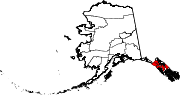 | |
| CDPs | ||
| Unincorporated community | ||
| Footnotes | ‡This populated place also has portions in adjacent boroughs or census areas | |
| ||


