National Register of Historic Places listings in Ketchikan Gateway Borough, Alaska

This is a list of the National Register of Historic Places listings in Ketchikan Gateway Borough, Alaska.
This is intended to be a complete list of the properties and districts on the National Register of Historic Places in Ketchikan Gateway Borough, Alaska, United States. The locations of National Register properties and districts for which the latitude and longitude coordinates are included below, may be seen in an online map.[1]
There are 20 properties and districts listed on the National Register in the borough. Another 2 properties were once listed but have been removed.
This National Park Service list is complete through NPS recent listings posted August 23, 2024.[2]
Map all coordinates using OpenStreetMap
Download coordinates as:
- KML
- GPX (all coordinates)
- GPX (primary coordinates)
- GPX (secondary coordinates)
Current listings
| [3] | Name on the Register[4] | Image | Date listed[5] | Location | City or town | Description |
|---|---|---|---|---|---|---|
| 1 | Alaska Totems |  | June 21, 1971 (#71001090) | Between Park Avenue and Deermount Avenue 55°20′33″N 131°38′03″W / 55.34262°N 131.63409°W / 55.34262; -131.63409 (Alaska Totems) | Ketchikan | Site of the Totem Heritage Center. |
| 2 | Burkhart-Dibrell House |  | September 8, 1982 (#82004902) | 500 Main Street 55°20′38″N 131°38′54″W / 55.34399°N 131.64841°W / 55.34399; -131.64841 (Burkhart-Dibrell House) | Ketchikan | |
| 3 | Chief Kashakes House |  | April 26, 1993 (#93000338) | Mile 2.5 of South Tongass Highway 55°19′05″N 131°35′49″W / 55.31816°N 131.59706°W / 55.31816; -131.59706 (Chief Kashakes House) | Saxman | |
| 4 | Clover Pass School | Upload image | August 22, 2005 (#05000898) | Potter Road off Knudson Cove Road 55°28′22″N 131°47′32″W / 55.47278°N 131.79221°W / 55.47278; -131.79221 (Clover Pass School) | Clover Pass | |
| 5 | Creek Street Historic District |  | August 6, 2014 (#14000454) | Creek Street, Married Man's Trail and Totem Way 55°20′33″N 131°38′31″W / 55.3424°N 131.64189°W / 55.3424; -131.64189 (Creek Street Historic District) | Ketchikan | |
| 6 | Downtown Ketchikan Historic District | 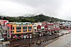 | October 2, 2017 (#16000467) | Front, Main, Mission, Dock & Mill Sts. 55°20′30″N 131°38′45″W / 55.341620°N 131.645719°W / 55.341620; -131.645719 (Downtown Ketchikan Historic District) | Ketchikan | |
| 7 | First Lutheran Church | 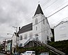 | May 18, 1987 (#87000716) | 1200 Tongass Avenue 55°20′43″N 131°39′28″W / 55.3452°N 131.65782°W / 55.3452; -131.65782 (First Lutheran Church) | Ketchikan | |
| 8 | Gilmore Building |  | September 27, 1989 (#89001415) | 326 Front Street 55°20′32″N 131°38′52″W / 55.34234°N 131.64781°W / 55.34234; -131.64781 (Gilmore Building) | Ketchikan | |
| 9 | Guard Island Lighthouse | 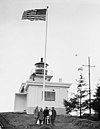 | January 14, 2004 (#03001378) | On Guard Island, at the northern end of Tongass Narrows, about 9.6 miles (15.4 km) northwest of Ketchikan 55°26′46″N 131°52′52″W / 55.44599°N 131.88117°W / 55.44599; -131.88117 (Guard Island Lighthouse) | Ketchikan | |
| 10 | Ketchikan Federal Building |  | April 28, 2006 (#05000897) | 648 Mission Street 55°20′30″N 131°38′34″W / 55.34158°N 131.64274°W / 55.34158; -131.64274 (Ketchikan Federal Building) | Ketchikan | |
| 11 | Ketchikan Ranger House |  | July 16, 1987 (#87000645) | 309 Gorge Street 55°20′47″N 131°39′34″W / 55.34651°N 131.65942°W / 55.34651; -131.65942 (Ketchikan Ranger House) | Ketchikan | |
| 12 | Mary Island Light Station |  | July 8, 2005 (#05000645) | Northeastern end of Mary Island, between Revillagigedo Channel and Felice Strait, about 6.4 miles (10.3 km) south of Revillagigedo Island 55°05′56″N 131°10′58″W / 55.09897°N 131.18265°W / 55.09897; -131.18265 (Mary Island Light Station) | Ketchikan | |
| 13 | Saxman Totem Park |  | August 7, 1979 (#79003758) | 2660 Killer Whale Avenue 55°19′11″N 131°35′47″W / 55.31971°N 131.59638°W / 55.31971; -131.59638 (Saxman Totem Park) | Saxman | |
| 14 | Stedman-Thomas Historic District |  | February 21, 1996 (#96000062) | Stedman Street, Thomas Street, Inman Street, Brown Way, and Tatsudu Street 55°20′26″N 131°38′25″W / 55.34062°N 131.64017°W / 55.34062; -131.64017 (Stedman-Thomas Historic District) | Ketchikan | |
| 15 | Storehouse No. 3 |  | December 7, 1977 (#77001575) | About 61 miles (98 km) east of Ketchikan, at the mouth of Halibut Bay 55°14′07″N 130°06′11″W / 55.23526°N 130.10292°W / 55.23526; -130.10292 (Storehouse No. 3) | Ketchikan | |
| 16 | The Star |  | April 26, 1993 (#93000336) | 5 Creek Street 55°20′33″N 131°38′33″W / 55.34247°N 131.64253°W / 55.34247; -131.64253 (The Star) | Ketchikan | Also a contributing property to Creek Street Historic District. |
| 17 | Totem Bight State Historic Site |  | October 27, 1970 (#70000916) | Mile 10.5 of North Tongass Highway 55°25′12″N 131°46′21″W / 55.42012°N 131.77251°W / 55.42012; -131.77251 (Totem Bight State Historic Site) | Ketchikan | |
| 18 | Tree Point Lighthouse |  | October 27, 2004 (#04001177) | Western coast of the mainland on eastern side of Revillagigedo Channel, about 47 miles (76 km) southeast of Ketchikan 54°48′10″N 130°56′02″W / 54.80285°N 130.93397°W / 54.80285; -130.93397 (Tree Point Lighthouse) | Ketchikan | |
| 19 | Walker-Broderick House |  | August 31, 1982 (#82004903) | 541 Pine Street 55°20′40″N 131°38′48″W / 55.34452°N 131.64676°W / 55.34452; -131.64676 (Walker-Broderick House) | Ketchikan | |
| 20 | Ziegler House |  | May 30, 1985 (#85001161) | 623 Grant Street 55°20′40″N 131°38′43″W / 55.34432°N 131.64527°W / 55.34432; -131.64527 (Ziegler House) | Ketchikan |
Former listings
| [3] | Name on the Register | Image | Date listed | Date removed | Location | City or town | Description |
|---|---|---|---|---|---|---|---|
| 1 | Ayson Hotel | Upload image | June 17, 1987 (#86003366) | June 4, 1990 | 301-305 Stedman Street | Ketchikan | Also known as the Dick Harris Marine Hardware. Demolished in May 1990 [6] |
| 2 | McKay Marine Ways | Upload image | September 26, 1998 (#88001569) | January 18, 1990 | 1935 Tongass Avenue | Ketchikan | Building demolished in 1989.[7][8][dead link] |
See also
Wikimedia Commons has media related to National Register of Historic Places in Ketchikan Gateway Borough, Alaska.
- List of National Historic Landmarks in Alaska
- National Register of Historic Places listings in Alaska
References
- ^ The latitude and longitude information provided in this table was derived originally from the National Register Information System, which has been found to be fairly accurate for about 99% of listings. Some locations in this table may have been corrected to current GPS standards.
- ^ National Park Service, United States Department of the Interior, "National Register of Historic Places: Weekly List Actions", retrieved August 23, 2024.
- ^ a b Numbers represent an alphabetical ordering by significant words. Various colorings, defined here, differentiate National Historic Landmarks and historic districts from other NRHP buildings, structures, sites or objects.
- ^ "National Register Information System". National Register of Historic Places. National Park Service. April 24, 2008.
- ^ The eight-digit number below each date is the number assigned to each location in the National Register Information System database, which can be viewed by clicking the number.
- ^ "Landmark Ayson Hotel In Ketchikan Demolished". Daily Sitka Sentinel. May 23, 1990. p. 10. Retrieved April 17, 2022 – via Newspapers.com.
- ^ "Down She Comes". Daily Sitka Sentinel. September 14, 1989. p. 1. Retrieved April 17, 2022 – via Newspapers.com.
- ^ "Ketchikan landmark demolished". January 22, 2001. Archived from the original on February 1, 2005. Retrieved May 24, 2017.
- v
- t
- e
- List of U.S. National Historic Landmarks by state:
- Alabama
- Alaska
- Arizona
- Arkansas
- California
- Colorado
- Connecticut
- Delaware
- Florida
- Georgia
- Hawaii
- Idaho
- Illinois
- Indiana
- Iowa
- Kansas
- Kentucky
- Louisiana
- Maine
- Maryland
- Massachusetts
- Michigan
- Minnesota
- Mississippi
- Missouri
- Montana
- Nebraska
- Nevada
- New Hampshire
- New Jersey
- New Mexico
- New York
- North Carolina
- North Dakota
- Ohio
- Oklahoma
- Oregon
- Pennsylvania
- Rhode Island
- South Carolina
- South Dakota
- Tennessee
- Texas
- Utah
- Vermont
- Virginia
- Washington
- West Virginia
- Wisconsin
- Wyoming
 National Register of Historic Places portal
 Category


| |||
|---|---|---|---|
Boroughs |  | ||
Census areas | |||
There are no sites listed on the National Register of Historic Places in Kusilvak Census Area. | |||
Municipalities and communities of Ketchikan Gateway Borough, Alaska, United States | ||
|---|---|---|
Borough seat: Ketchikan | ||
| Cities |  | |
| CDPs | ||
| Unincorporated community | ||
| Ghost towns | ||
Hyder is an exclave of the Ketchikan Gateway Borough and is located in the Prince of Wales–Hyder Census Area. | ||
| ||


