National Register of Historic Places listings in Chugach Census Area, Alaska

This is a list of the National Register of Historic Places listings in Chugach Census Area, Alaska.
This is intended to be a complete list of the properties and districts on the National Register of Historic Places in Chugach Census Area, Alaska, United States. The locations of National Register properties and districts for which the latitude and longitude coordinates are included below, may be seen in a Google map.[1]
There are 10 properties and districts listed on the National Register in the census area, including 2 National Historic Landmarks. Another property was once listed but has been removed.
This National Park Service list is complete through NPS recent listings posted August 23, 2024.[2]
Map this section's coordinates using OpenStreetMap
Download coordinates as:
- KML
- GPX (all coordinates)
- GPX (primary coordinates)
- GPX (secondary coordinates)
Current listings
| [3] | Name on the Register[4] | Image | Date listed[5] | Location | City or town | Description |
|---|---|---|---|---|---|---|
| 1 | Bering Expedition Landing Site |  | July 20, 1977 (#77001542) | On Kayak Island 59°53′40″N 144°29′08″W / 59.89444°N 144.48556°W / 59.89444; -144.48556 (Bering Expedition Landing Site) | Katalla | |
| 2 | Cape Hinchinbrook Light Station |  | July 29, 2005 (#05000728) | Southwestern end of Hinchinbrook Island 60°14′14″N 146°38′48″W / 60.23734°N 146.64665°W / 60.23734; -146.64665 (Cape Hinchinbrook Light Station) | Cordova | |
| 3 | Cape St. Elias Lighthouse |  | December 18, 1975 (#75002157) | Southwestern end of Kayak Island 59°47′54″N 144°35′56″W / 59.79844°N 144.59897°W / 59.79844; -144.59897 (Cape St. Elias Lighthouse) | Katalla | |
| 4 | Chilkat Oil Company Refinery Site | Upload image | September 6, 1974 (#74002320) | Along Katalla Slough, about 2.7 miles (4.3 km) east of Katalla 60°11′15″N 144°27′02″W / 60.18737°N 144.45047°W / 60.18737; -144.45047 (Chilkat Oil Company Refinery Site) | Katalla | |
| 5 | Cordova Post Office and Courthouse | 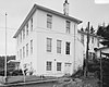 | August 2, 1977 (#77001571) | 612 2nd Street 60°32′39″N 145°45′24″W / 60.54411°N 145.75662°W / 60.54411; -145.75662 (Cordova Post Office and Courthouse) | Cordova | |
| 6 | Million Dollar Bridge | 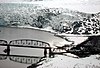 | March 31, 2000 (#00000293) | Mile 48 of Copper River Highway, about 35 miles (56 km) northeast of Cordova 60°40′23″N 144°44′45″W / 60.6731°N 144.74583°W / 60.6731; -144.74583 (Million Dollar Bridge) | Cordova | |
| 7 | Palugvik Archeological District | Upload image | October 15, 1966 (#66000957) | Hawkins Island | Cordova | |
| 8 | Pioneer Igloo Hall Number 19 | Upload image | August 15, 2012 (#12000492) | 621 1st Street 60°32′38″N 145°45′33″W / 60.54388°N 145.75912°W / 60.54388; -145.75912 (Pioneer Igloo Hall Number 19) | Cordova | |
| 9 | Red Dragon Historic District |  | August 31, 1982 (#82004899) | Roughly bounded by Lake Avenue, 1st Street and 2nd Street 60°32′32″N 145°45′28″W / 60.54216°N 145.75781°W / 60.54216; -145.75781 (Red Dragon Historic District) | Cordova | |
| 10 | St. Michael the Archangel Church | 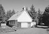 | June 6, 1980 (#80004578) | Southern side of Lake Avenue, between 9th Street and Birch Street 60°32′33″N 145°44′40″W / 60.54248°N 145.74431°W / 60.54248; -145.74431 (St. Michael the Archangel Church) | Cordova |
Former listings
| [3] | Name on the Register | Image | Date listed | Date removed | Location | City or town | Description |
|---|---|---|---|---|---|---|---|
| 1 | Reception Building | Upload image | April 9, 1980 (#80004566) | April 26, 2019 | Northeastern corner of 2nd Street and Browning Avenue 60°32′41″N 145°45′24″W / 60.54471°N 145.75667°W / 60.54471; -145.75667 (Reception Building) | Cordova |
See also
Wikimedia Commons has media related to National Register of Historic Places in Chugach Census Area, Alaska.
- List of National Historic Landmarks in Alaska
- National Register of Historic Places listings in Alaska
References
- ^ The latitude and longitude information provided in this table was derived originally from the National Register Information System, which has been found to be fairly accurate for about 99% of listings. Some locations in this table may have been corrected to current GPS standards.
- ^ National Park Service, United States Department of the Interior, "National Register of Historic Places: Weekly List Actions", retrieved August 23, 2024.
- ^ a b Numbers represent an alphabetical ordering by significant words. Various colorings, defined here, differentiate National Historic Landmarks and historic districts from other NRHP buildings, structures, sites or objects.
- ^ "National Register Information System". National Register of Historic Places. National Park Service. April 24, 2008.
- ^ The eight-digit number below each date is the number assigned to each location in the National Register Information System database, which can be viewed by clicking the number.
- v
- t
- e
- List of U.S. National Historic Landmarks by state:
- Alabama
- Alaska
- Arizona
- Arkansas
- California
- Colorado
- Connecticut
- Delaware
- Florida
- Georgia
- Hawaii
- Idaho
- Illinois
- Indiana
- Iowa
- Kansas
- Kentucky
- Louisiana
- Maine
- Maryland
- Massachusetts
- Michigan
- Minnesota
- Mississippi
- Missouri
- Montana
- Nebraska
- Nevada
- New Hampshire
- New Jersey
- New Mexico
- New York
- North Carolina
- North Dakota
- Ohio
- Oklahoma
- Oregon
- Pennsylvania
- Rhode Island
- South Carolina
- South Dakota
- Tennessee
- Texas
- Utah
- Vermont
- Virginia
- Washington
- West Virginia
- Wisconsin
- Wyoming
 National Register of Historic Places portal
 Category


| |||
|---|---|---|---|
Boroughs |  | ||
Census areas | |||
There are no sites listed on the National Register of Historic Places in Kusilvak Census Area. | |||


