National Register of Historic Places listings in Catawba County, North Carolina
Map all coordinates using OpenStreetMap
Download coordinates as:
- KML
- GPX (all coordinates)
- GPX (primary coordinates)
- GPX (secondary coordinates)

This list includes properties and districts listed on the National Register of Historic Places in Catawba County, North Carolina. Click the "Map of all coordinates" link to the right to view an online map of all properties and districts with latitude and longitude coordinates in the table below.[1]
Current listings
This National Park Service list is complete through NPS recent listings posted July 12, 2024.[2]
| [3] | Name on the Register[4] | Image | Date listed[5] | Location | City or town | Description |
|---|---|---|---|---|---|---|
| 1 | Abraham Anthony Farm |  | May 10, 1990 (#90000738) | West side of SR 1008, 0.5 miles (0.80 km) south of the junction with SR 2021 35°34′28″N 81°18′38″W / 35.574444°N 81.310556°W / 35.574444; -81.310556 (Abraham Anthony Farm) | Blackburn | |
| 2 | Balls Creek Campground |  | April 27, 1990 (#90000662) | West side of SR 1003, 0.1 miles (0.16 km) south of SR 1943 35°37′46″N 81°05′50″W / 35.629444°N 81.097222°W / 35.629444; -81.097222 (Balls Creek Campground) | Bandy's Crossroads | |
| 3 | Bandy Farms Historic District | Upload image | April 27, 1990 (#90000663) | East side of SR 1003, 0.5 miles (0.80 km)-0.85 miles (1.37 km) south of SR 1813 junction 35°37′51″N 81°05′35″W / 35.630833°N 81.093056°W / 35.630833; -81.093056 (Bandy Farms Historic District) | Bandy's Crossroads | |
| 4 | Bolick Historic District | Upload image | July 5, 1990 (#90001032) | First Ave. S. between US 64/70 and 12th St. 35°41′49″N 81°13′15″W / 35.696944°N 81.220833°W / 35.696944; -81.220833 (Bolick Historic District) | Conover | |
| 5 | Bost-Burris House | Upload image | July 5, 1990 (#90001033) | Junction of SR 1149 and SR 1154 35°40′00″N 81°14′58″W / 35.666667°N 81.249444°W / 35.666667; -81.249444 (Bost-Burris House) | Newton | |
| 6 | Bunker Hill Covered Bridge |  | February 26, 1970 (#70000446) | 2 miles (3.2 km) east of Claremont on US 70 35°43′20″N 81°06′36″W / 35.722222°N 81.11°W / 35.722222; -81.11 (Bunker Hill Covered Bridge) | Claremont | |
| 7 | Catawba County Courthouse |  | May 10, 1979 (#79001690) | S. Main, W.A, S. College, and W. 1st Sts. 35°39′47″N 81°13′19″W / 35.663056°N 81.221944°W / 35.663056; -81.221944 (Catawba County Courthouse) | Newton | |
| 8 | Catawba Historic District | Upload image | April 28, 1986 (#86000893) | Roughly bounded by Second Ave. NE, Third and Second Sts. SE, Second Ave. SW and NC 10, and Second St. SW 35°42′26″N 81°04′30″W / 35.707222°N 81.075°W / 35.707222; -81.075 (Catawba Historic District) | Catawba | |
| 9 | Claremont High School Historic District |  | October 23, 1986 (#86003357) | Roughly bounded by Fifth and Third Aves., Third St., Second Ave. and N. Center St.; also 505-753 N. Center St., 102-126 and 401 2nd Ave., NE., 406-602 3rd Ave., NE., 12-118 5th Ave., NW., and 212-258 5th Ave. 35°44′08″N 81°20′41″W / 35.735556°N 81.344722°W / 35.735556; -81.344722 (Claremont High School Historic District) | Hickory | Second set of boundaries represents a boundary increase of December 18, 2009 |
| 10 | Elliott-Carnegie Library |  | March 15, 1985 (#85000584) | 415 1st Ave. NW 35°43′58″N 81°20′42″W / 35.732778°N 81.345°W / 35.732778; -81.345 (Elliott-Carnegie Library) | Hickory | |
| 11 | First Presbyterian Church |  | March 15, 1985 (#85000585) | 2nd St. and 3rd Ave. NW 35°44′07″N 81°20′25″W / 35.735278°N 81.340278°W / 35.735278; -81.340278 (First Presbyterian Church) | Hickory | |
| 12 | Foil-Cline House | Upload image | July 5, 1990 (#90001034) | 406 S. Main Ave. 35°39′29″N 81°13′29″W / 35.658056°N 81.224722°W / 35.658056; -81.224722 (Foil-Cline House) | Newton | |
| 13 | Dr. Glenn R. Frye House |  | August 5, 2009 (#09000600) | 539 N. Center St., NE 35°44′22″N 81°20′17″W / 35.739444°N 81.338056°W / 35.739444; -81.338056 (Dr. Glenn R. Frye House) | Hickory | |
| 14 | Clement Geitner House |  | March 15, 1985 (#85000703) | 436 Main Ave. NW 35°43′57″N 81°20′45″W / 35.7325°N 81.345833°W / 35.7325; -81.345833 (Clement Geitner House) | Hickory | |
| 15 | Lee & Helen George House |  | April 24, 2012 (#12000234) | 16 9th Ave., NE 35°44′41″N 81°20′14″W / 35.744623°N 81.337325°W / 35.744623; -81.337325 (Lee & Helen George House) | Hickory | |
| 16 | Grace Reformed Church | 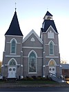 | July 5, 1990 (#90001035) | 201-211 S. Main Ave. 35°39′40″N 81°13′23″W / 35.661111°N 81.223056°W / 35.661111; -81.223056 (Grace Reformed Church) | Newton | |
| 17 | Grace Union Church and Cemetery |  | May 10, 1990 (#90000739) | Junction of SR 1008 and SR 2030 35°35′56″N 81°19′02″W / 35.598889°N 81.317222°W / 35.598889; -81.317222 (Grace Union Church and Cemetery) | Blackburn | |
| 18 | Harris Arcade |  | May 8, 2008 (#08000378) | 221-229 1st Ave. NW. 35°43′59″N 81°20′26″W / 35.733056°N 81.340556°W / 35.733056; -81.340556 (Harris Arcade) | Hickory | |
| 19 | Hickory Municipal Building | 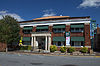 | February 18, 2000 (#00000119) | 30 Third St., SW 35°43′57″N 81°20′32″W / 35.7325°N 81.342222°W / 35.7325; -81.342222 (Hickory Municipal Building) | Hickory | |
| 20 | Hickory Southwest Downtown Historic District |  | December 16, 2005 (#05001409) | Portions of Government Ave.SE, Second Street Place SE, First Ave. SW and Third St. SW 35°43′51″N 81°20′28″W / 35.730833°N 81.341111°W / 35.730833; -81.341111 (Hickory Southwest Downtown Historic District) | Hickory | |
| 21 | Highland School |  | June 1, 1990 (#90000824) | 1017 10th Ave. NE. 35°44′33″N 81°18′59″W / 35.7425°N 81.316389°W / 35.7425; -81.316389 (Highland School) | Hickory | |
| 22 | Hollar Hosiery Mills-Knit Sox Knitting Mills |  | December 26, 2012 (#12001087) | 883 Highland Ave., SE 35°44′07″N 81°19′34″W / 35.735278°N 81.326111°W / 35.735278; -81.326111 (Hollar Hosiery Mills-Knit Sox Knitting Mills) | Hickory | |
| 23 | Houck's Chapel | 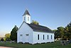 | March 15, 1985 (#85000587) | 9th Ave. and 17th St. NW 35°44′41″N 81°22′07″W / 35.744722°N 81.368611°W / 35.744722; -81.368611 (Houck's Chapel) | Hickory | |
| 24 | George Huffman Farm | Upload image | June 21, 1990 (#90000861) | SR 1479, southeast of the junction with Tate Blvd. 35°42′45″N 81°15′16″W / 35.7125°N 81.254444°W / 35.7125; -81.254444 (George Huffman Farm) | Conover | |
| 25 | Keever-Cansler Farm | Upload image | May 10, 1990 (#90000740) | East side of SR 2024, 0.05 miles (0.080 km) north of the junction with SR 2026 35°34′48″N 81°19′33″W / 35.58°N 81.325833°W / 35.58; -81.325833 (Keever-Cansler Farm) | Blackburn | |
| 26 | Kenworth Historic District |  | May 9, 1985 (#85001054) | Roughly bounded by 2nd Ave., 5th St. and 3rd Ave. Dr. SE; also roughly along 5th St., SE., 5th Ave., SE., 3rd Ave. Dr., SE., and 2nd Ave., SE. 35°43′40″N 81°19′45″W / 35.727778°N 81.329167°W / 35.727778; -81.329167 (Kenworth Historic District) | Hickory | Second set of boundaries represents a boundary increase of May 18, 2005 |
| 27 | John A. Lentz House |  | March 15, 1985 (#85000588) | 321 9th St. NW 35°44′11″N 81°21′09″W / 35.736389°N 81.3525°W / 35.736389; -81.3525 (John A. Lentz House) | Hickory | |
| 28 | Long, McCorkle and Murray Houses | Upload image | September 5, 1990 (#90001371) | 1310-1326 N. Main Ave. 35°40′35″N 81°13′16″W / 35.676389°N 81.221111°W / 35.676389; -81.221111 (Long, McCorkle and Murray Houses) | Newton | |
| 29 | Lyerly Full Fashioned Mill |  | August 8, 2007 (#06001137) | 56 Third St., SE 35°44′01″N 81°19′59″W / 35.733611°N 81.333056°W / 35.733611; -81.333056 (Lyerly Full Fashioned Mill) | Hickory | |
| 30 | Memorial Reformed Church |  | June 21, 1990 (#90000865) | 201 E. Main St. 35°34′30″N 81°12′36″W / 35.575°N 81.21°W / 35.575; -81.21 (Memorial Reformed Church) | Maiden | |
| 31 | Miller-Cansler House | Upload image | May 10, 1990 (#90000741) | North side of SR 2007, 0.5 miles (0.80 km) east of the junction with SR 1005 35°35′47″N 81°15′14″W / 35.596389°N 81.253889°W / 35.596389; -81.253889 (Miller-Cansler House) | Maiden | |
| 32 | Alexander Moore Farm | Upload image | April 27, 1990 (#90000664) | SR 2646 0.5 miles (0.80 km) northwest of SR 1004 junction 35°42′05″N 81°00′02″W / 35.701389°N 81.000556°W / 35.701389; -81.000556 (Alexander Moore Farm) | Catawba | |
| 33 | John Alfred Moretz House | 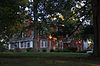 | March 15, 1985 (#85000589) | 1437 - 6th St. Circle NW 35°45′23″N 81°21′06″W / 35.756389°N 81.351667°W / 35.756389; -81.351667 (John Alfred Moretz House) | Hickory | |
| 34 | Munday House | Upload image | August 22, 1975 (#75001246) | Address Restricted | Denver | |
| 35 | Murray's Mill Historic District |  | December 31, 1979 (#79001689) | Southeast of Catawba 35°40′27″N 81°05′44″W / 35.674167°N 81.095556°W / 35.674167; -81.095556 (Murray's Mill Historic District) | Catawba | |
| 36 | Neill-Turner-Lester House | Upload image | May 10, 1990 (#90000742) | North side of SR 1836, 0.25 miles (0.40 km) northeast of the junction with SR 1837 35°38′59″N 80°57′48″W / 35.649722°N 80.963333°W / 35.649722; -80.963333 (Neill-Turner-Lester House) | Sherrills Ford | |
| 37 | Newton Downtown Historic District |  | May 1, 2012 (#12000253) | Roughly bounded by 2nd & A Sts., & N. Forney, & N. Ashe Aves. 35°39′48″N 81°13′17″W / 35.663389°N 81.221325°W / 35.663389; -81.221325 (Newton Downtown Historic District) | Newton | |
| 38 | North Main Avenue Historic District | Upload image | May 22, 1986 (#86001147) | Roughly bounded by W. Ninth St., N. Main Ave., W. Fourth and W. Sixth Sts., N. Deal Ave., and W. Eighth St. 35°40′08″N 81°13′26″W / 35.668889°N 81.223889°W / 35.668889; -81.223889 (North Main Avenue Historic District) | Newton | |
| 39 | Oakwood Historic District | 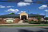 | March 25, 1986 (#86000687) | Roughly bounded by Oakwood Cemetery and Fourth Ave. NW, Fourth St. NW, Second Ave. NW, and Sixth St. NW; also portions of 1st Ave. NW, 2nd Ave. NW, 2nd St. NW, 2nd Pl. NW, 3rd Ave. NW, 3rd St. NW, 4th Ave. NW, 4 Ave. Dr. NW, 4th St. NW, 5th St. NW, 6th St. NW, 7th St. NW, 8th St. NW, and N. Center St., and by 8th St. NW, 6th Ave. NW, N. Center St., and 1st. Ave., 35°44′15″N 81°20′43″W / 35.7375°N 81.345278°W / 35.7375; -81.345278 (Oakwood Historic District) | Hickory | Second set of addresses represent a boundary increase approved May 8, 2019 |
| 40 | Perkins House | Upload image | October 1, 1974 (#74001336) | North of Catawba off I-40 35°44′00″N 81°04′23″W / 35.733333°N 81.073056°W / 35.733333; -81.073056 (Perkins House) | Newton | |
| 41 | Piedmont Wagon Company | 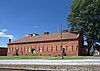 | March 15, 1985 (#85000592) | Main Ave. NW 35°43′56″N 81°21′17″W / 35.732222°N 81.354722°W / 35.732222; -81.354722 (Piedmont Wagon Company) | Hickory | |
| 42 | Powell-Trollinger Lime Kilns | Upload image | November 8, 1974 (#74001337) | South of Catawba 35°39′11″N 81°03′51″W / 35.653056°N 81.064167°W / 35.653056; -81.064167 (Powell-Trollinger Lime Kilns) | Catawba | |
| 43 | Propst House |  | April 24, 1973 (#73001312) | Shuford Memorial Garden 35°44′12″N 81°20′49″W / 35.736778°N 81.346917°W / 35.736778; -81.346917 (Propst House) | Hickory | |
| 44 | David F. Propst House | Upload image | June 21, 1990 (#90000864) | Junction of SR 1810 and SR 1878 35°35′51″N 81°11′08″W / 35.5975°N 81.185556°W / 35.5975; -81.185556 (David F. Propst House) | Maiden | |
| 45 | Franklin D. Reinhardt and Harren-Hood Farms | Upload image | June 21, 1990 (#90000863) | SR 2013 northwest of the junction with SR 2012 35°37′05″N 81°14′21″W / 35.618056°N 81.239167°W / 35.618056; -81.239167 (Franklin D. Reinhardt and Harren-Hood Farms) | Maiden | |
| 46 | William Pinckney Reinhardt House | Upload image | July 19, 1990 (#90001111) | Junction of SR 2012 and SR 2013 35°36′20″N 81°14′15″W / 35.605556°N 81.2375°W / 35.605556; -81.2375 (William Pinckney Reinhardt House) | Maiden | |
| 47 | Ridgeview Public Library, (Former) |  | May 12, 2011 (#11000294) | 415 1st St., S.W. 35°43′37″N 81°20′20″W / 35.726944°N 81.338889°W / 35.726944; -81.338889 (Ridgeview Public Library, (Former)) | Hickory | |
| 48 | Rock Barn Farm | Upload image | July 5, 1990 (#90001036) | West side of SR 1709, 0.4 miles (0.64 km) north of the junction with SR 1715 35°44′32″N 81°09′39″W / 35.742222°N 81.160833°W / 35.742222; -81.160833 (Rock Barn Farm) | Claremont | |
| 49 | Rudisill-Wilson House | Upload image | August 14, 1973 (#73001315) | Southwest of Newton off NC 10 35°36′58″N 81°15′23″W / 35.616111°N 81.256389°W / 35.616111; -81.256389 (Rudisill-Wilson House) | Newton | |
| 50 | Self-Trott-Bickett House | Upload image | July 5, 1990 (#90001037) | 331 S. College Ave. 35°39′32″N 81°13′22″W / 35.658889°N 81.222778°W / 35.658889; -81.222778 (Self-Trott-Bickett House) | Newton | |
| 51 | Sharpe-Gentry Farm | Upload image | June 21, 1990 (#90000859) | Junction of NC 10 and SR 1137 35°37′41″N 81°22′22″W / 35.628056°N 81.372778°W / 35.628056; -81.372778 (Sharpe-Gentry Farm) | Propst Crossroads | |
| 52 | Miles Alexander Sherrill House | Upload image | April 27, 1990 (#90000665) | West side of SR 1849, 0.1 miles (0.16 km) south of SR 1848 junction 35°37′37″N 81°00′28″W / 35.626944°N 81.007778°W / 35.626944; -81.007778 (Miles Alexander Sherrill House) | Sherrills Ford | |
| 53 | Shuford House |  | April 24, 1973 (#73001313) | 542 2nd St. NE. 35°44′26″N 81°20′00″W / 35.740556°N 81.333333°W / 35.740556; -81.333333 (Shuford House) | Hickory | |
| 54 | Shuford-Hoover House | Upload image | May 10, 1990 (#90000743) | East side of SR 1008, 0.05 miles (0.080 km) south of the junction with SR 10 35°37′24″N 81°19′16″W / 35.623333°N 81.321111°W / 35.623333; -81.321111 (Shuford-Hoover House) | Blackburn | |
| 55 | St. Paul's Church and Cemetery | 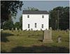 | December 9, 1971 (#71000573) | Junction of SR 1149 and SR 1164 35°40′35″N 81°14′38″W / 35.676389°N 81.243889°W / 35.676389; -81.243889 (St. Paul's Church and Cemetery) | Newton | |
| 56 | St. Paul's Reformed Church |  | June 21, 1990 (#90000860) | Junction of SR 1151 and SR 1005 35°38′52″N 81°16′05″W / 35.647778°N 81.268056°W / 35.647778; -81.268056 (St. Paul's Reformed Church) | Startown | |
| 57 | Terrell Historic District | Upload image | July 15, 1986 (#86001685) | NC 150 and SR 1848 35°33′34″N 80°58′38″W / 35.559444°N 80.977222°W / 35.559444; -80.977222 (Terrell Historic District) | Terrell | |
| 58 | Warlick-Huffman Farm | Upload image | June 21, 1990 (#90000862) | SR 1116 northwest of the junction with NC 10 35°37′04″N 81°24′48″W / 35.617778°N 81.413333°W / 35.617778; -81.413333 (Warlick-Huffman Farm) | Propst Crossroads | |
| 59 | Weidner Rock House | Upload image | December 4, 1973 (#73001314) | South of Hickory on SR 1142 35°38′42″N 81°18′35″W / 35.645°N 81.309722°W / 35.645; -81.309722 (Weidner Rock House) | Hickory | |
| 60 | Wesley's Chapel Arbor and Cemetery | Upload image | May 10, 1990 (#90000744) | West side of SR 2033, 0.4 miles (0.64 km) south of the junction with SR 10 35°36′55″N 81°20′55″W / 35.615278°N 81.348611°W / 35.615278; -81.348611 (Wesley's Chapel Arbor and Cemetery) | Blackburn | |
| 61 | Whisnant Hosiery Mills |  | August 27, 2013 (#13000637) | 74 8th St., SE. 35°43′59″N 81°19′36″W / 35.733056°N 81.326667°W / 35.733056; -81.326667 (Whisnant Hosiery Mills) | Hickory | |
| 62 | Wilfong-Wilson Farm | Upload image | June 21, 1990 (#90000858) | SR 1145, southwest of the junction with SR 1146 35°38′41″N 81°17′40″W / 35.644722°N 81.294444°W / 35.644722; -81.294444 (Wilfong-Wilson Farm) | Startown | |
| 63 | Yoder's Mills Historic District | Upload image | January 11, 1980 (#80002806) | Address Restricted | Hickory |
Former listing
| [3] | Name on the Register | Image | Date listed | Date removed | Location | City or town | Description |
|---|---|---|---|---|---|---|---|
| 1 | Second Street Place Southwest Historic District | Upload image | August 11, 1985 (#85001790) | May 5, 1986 | Roughly bounded by Main Ave. Pl., 2nd Ave. Pl., and 1st Ave. SW | Hickory | Delisted due to procedural errors; relisted in 2005 as the Hickory Southwest Downtown Historic District |
See also
Wikimedia Commons has media related to National Register of Historic Places in Catawba County, North Carolina.
- National Register of Historic Places listings in North Carolina
- List of National Historic Landmarks in North Carolina
References
- ^ The latitude and longitude information provided in this table was derived originally from the National Register Information System, which has been found to be fairly accurate for about 99% of listings. Some locations in this table may have been corrected to current GPS standards.
- ^ National Park Service, United States Department of the Interior, "National Register of Historic Places: Weekly List Actions", retrieved July 12, 2024.
- ^ a b Numbers represent an alphabetical ordering by significant words. Various colorings, defined here, differentiate National Historic Landmarks and historic districts from other NRHP buildings, structures, sites or objects.
- ^ "National Register Information System". National Register of Historic Places. National Park Service. April 24, 2008.
- ^ The eight-digit number below each date is the number assigned to each location in the National Register Information System database, which can be viewed by clicking the number.
- v
- t
- e

by county
- Alamance
- Alexander
- Alleghany
- Anson
- Ashe
- Avery
- Beaufort
- Bertie
- Bladen
- Brunswick
- Buncombe
- Burke
- Cabarrus
- Caldwell
- Camden
- Carteret
- Caswell
- Catawba
- Chatham
- Cherokee
- Chowan
- Clay
- Cleveland
- Columbus
- Craven
- Cumberland
- Currituck
- Dare
- Davidson
- Davie
- Duplin
- Durham
- Edgecombe
- Forsyth
- Franklin
- Gaston
- Gates
- Graham
- Granville
- Greene
- Guilford
- Halifax
- Harnett
- Haywood
- Henderson
- Hertford
- Hoke
- Hyde
- Iredell
- Jackson
- Johnston
- Jones
- Lee
- Lenoir
- Lincoln
- Macon
- Madison
- Martin
- McDowell
- Mecklenburg
- Mitchell
- Montgomery
- Moore
- Nash
- New Hanover
- Northampton
- Onslow
- Orange
- Pamlico
- Pasquotank
- Pender
- Perquimans
- Person
- Pitt
- Polk
- Randolph
- Richmond
- Robeson
- Rockingham
- Rowan
- Rutherford
- Sampson
- Scotland
- Stanly
- Stokes
- Surry
- Swain
- Transylvania
- Tyrrell
- Union
- Vance
- Wake
- Warren
- Washington
- Watauga
- Wayne
- Wilkes
- Wilson
- Yadkin
- Yancey
| |
|---|---|
| Topics | |
| Lists by state |
|
| Lists by insular areas | |
| Lists by associated state | |
| Other areas | |
| Related | |
| |


Municipalities and communities of Catawba County, North Carolina, United States | ||
|---|---|---|
County seat: Newton | ||
| Cities | 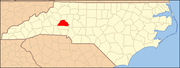 | |
| Towns | ||
| CDPs | ||
| Unincorporated communities |
| |
| Footnotes | ‡This populated place also has portions in an adjacent county or counties | |
| ||


