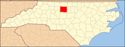
National Register of Historic Places listings in Guilford County, North Carolina
Map all coordinates using OpenStreetMap
Download coordinates as:
- KML
- GPX (all coordinates)
- GPX (primary coordinates)
- GPX (secondary coordinates)
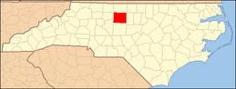
This list includes properties and districts listed on the National Register of Historic Places in Guilford County, North Carolina. Click the "Map of all coordinates" link to the right to view an online map of all properties and districts with latitude and longitude coordinates in the table below.[1]
This National Park Service list is complete through NPS recent listings posted July 12, 2024.[2]
Current listings
| [3] | Name on the Register[4] | Image | Date listed[5] | Location | City or town | Description |
|---|---|---|---|---|---|---|
| 1 | John H. Adams House |  | January 11, 2001 (#00001641) | 1108 N. Main St. 35°58′12″N 80°00′54″W / 35.970000°N 80.015000°W / 35.970000; -80.015000 (John H. Adams House) | High Point | |
| 2 | Agricultural and Technical College of North Carolina Historic District | 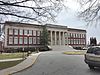 | October 20, 1988 (#88002046) | E. side of Dudley St. between Bluford St. and Headen Dr. 36°04′28″N 79°46′39″W / 36.074444°N 79.7775°W / 36.074444; -79.7775 (Agricultural and Technical College of North Carolina Historic District) | Greensboro | |
| 3 | Col. Isaac Beeson House | Upload image | October 16, 1980 (#80002836) | South of Colfax 36°04′29″N 80°01′20″W / 36.074722°N 80.022222°W / 36.074722; -80.022222 (Col. Isaac Beeson House) | Colfax | |
| 4 | Charles Benbow House | Upload image | August 19, 1982 (#82004842) | South of Oak Ridge on NC 150 36°09′49″N 79°59′33″W / 36.163611°N 79.9925°W / 36.163611; -79.9925 (Charles Benbow House) | Oak Ridge | |
| 5 | Jesse Benbow House II | Upload image | September 8, 1983 (#83001885) | NC 150 36°09′50″N 80°00′08″W / 36.163889°N 80.002222°W / 36.163889; -80.002222 (Jesse Benbow House II) | Oak Ridge | |
| 6 | Bennett College Historic District |  | April 3, 1992 (#92000179) | Roughly bounded by E. Washington, Bennett and Gorrell Sts. 36°04′03″N 79°46′47″W / 36.0675°N 79.779722°W / 36.0675; -79.779722 (Bennett College Historic District) | Greensboro | |
| 7 | Blandwood |  | April 17, 1970 (#70000455) | 447 W. Washington St. 36°04′09″N 79°47′38″W / 36.069167°N 79.793889°W / 36.069167; -79.793889 (Blandwood) | Greensboro | |
| 8 | Blue Bell Company Plant | Upload image | November 27, 2020 (#100005841) | 620 South Elm St. 36°03′54″N 79°47′27″W / 36.0650°N 79.7909°W / 36.0650; -79.7909 (Blue Bell Company Plant) | Greensboro | |
| 9 | Buffalo Presbyterian Church and Cemetery | 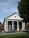 | September 16, 2002 (#02000985) | 800 and 803 Sixteenth St. 36°06′33″N 79°46′49″W / 36.109167°N 79.780278°W / 36.109167; -79.780278 (Buffalo Presbyterian Church and Cemetery) | Greensboro | |
| 10 | Bumpas-Troy House |  | December 6, 1977 (#77001000) | 114 S. Mendenhall St. 36°04′20″N 79°48′12″W / 36.072222°N 79.803333°W / 36.072222; -79.803333 (Bumpas-Troy House) | Greensboro | |
| 11 | David Caldwell Log College Site |  | January 13, 1982 (#82003456) | Address Restricted | Greensboro | |
| 12 | Carolina Cadillac Company Building |  | August 25, 2014 (#14000520) | 304 E. Market St. 36°04′19″N 79°47′12″W / 36.0720°N 79.7866°W / 36.0720; -79.7866 (Carolina Cadillac Company Building) | Greensboro | |
| 13 | Carolina Casket Company | 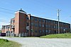 | April 15, 2015 (#15000163) | 812 Millis St. 35°56′54″N 80°00′59″W / 35.9483°N 80.0163°W / 35.9483; -80.0163 (Carolina Casket Company) | High Point | |
| 14 | Wilbur and Martha Carter House |  | August 13, 2008 (#08000777) | 1012 Country Club Dr. 36°05′56″N 79°48′32″W / 36.098786°N 79.809008°W / 36.098786; -79.809008 (Wilbur and Martha Carter House) | Greensboro | |
| 15 | Central Fire Station |  | April 28, 1980 (#80002837) | 318 N. Greene St. 36°04′33″N 79°47′29″W / 36.075833°N 79.791389°W / 36.075833; -79.791389 (Central Fire Station) | Greensboro | |
| 16 | College Hill Historic District |  | November 4, 1993 (#93001191) | Roughly bounded by W. Market St., S. Cedar St., Oakland Ave. and McIver St. 36°04′08″N 79°48′12″W / 36.068889°N 79.803333°W / 36.068889; -79.803333 (College Hill Historic District) | Greensboro | |
| 17 | Deep River Friends Meeting House and Cemetery | Upload image | December 13, 1995 (#95001448) | 5300 W. Wendover Ave. 36°01′53″N 79°57′55″W / 36.031389°N 79.965278°W / 36.031389; -79.965278 (Deep River Friends Meeting House and Cemetery) | High Point | |
| 18 | Dixon-Leftwich-Murphy House |  | September 23, 1982 (#82003457) | 507 Church St. 36°04′46″N 79°47′13″W / 36.079444°N 79.786944°W / 36.079444; -79.786944 (Dixon-Leftwich-Murphy House) | Greensboro | |
| 19 | Downtown Greensboro Historic District |  | June 17, 1982 (#82003458) | Elm, S. Davie, S. Green, and E. and W. Washington Sts.; also roughly bounded by Davie, North Elm, North and South Green, East and West Lewis, West Market, and West Washington Sts., East and West Friendly and Summit Aves., West Gate City Blvd, and Southern Railway right of way 36°04′07″N 79°47′25″W / 36.068611°N 79.790278°W / 36.068611; -79.790278 (Downtown Greensboro Historic District) | Greensboro | Second set of addresses represent a boundary adjustment approved April 20, 2023. |
| 20 | James Benson Dudley Senior High School and Gymnasium |  | April 11, 2003 (#03000302) | 1200 Lincoln St. 36°03′35″N 79°45′54″W / 36.059722°N 79.765°W / 36.059722; -79.765 (James Benson Dudley Senior High School and Gymnasium) | Greensboro | |
| 21 | Endsley-Morgan House | Upload image | October 25, 1984 (#84000117) | Off U.S. 421 36°07′23″N 80°00′51″W / 36.123056°N 80.014167°W / 36.123056; -80.014167 (Endsley-Morgan House) | Colfax | |
| 22 | Enterprise Building |  | December 2, 2014 (#14000985) | 305 N. Main St. 35°57′34″N 80°00′26″W / 35.9594°N 80.0073°W / 35.9594; -80.0073 (Enterprise Building) | High Point | |
| 23 | William Fields House |  | December 5, 1985 (#85003084) | 447 Arlington St. 36°03′54″N 79°47′21″W / 36.065°N 79.789167°W / 36.065; -79.789167 (William Fields House) | Greensboro | |
| 24 | First Baptist Church |  | January 8, 2009 (#08001289) | 701 E. Washington Dr. 35°57′41″N 79°59′59″W / 35.961408°N 79.999703°W / 35.961408; -79.999703 (First Baptist Church) | High Point | |
| 25 | Fisher Park Historic District | 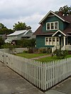 | January 22, 1992 (#91002006) | Roughly bounded by Fisher and Bessemer Aves. and Wharton and Church Sts.; also 507 N. Church St. 36°04′59″N 79°47′26″W / 36.083056°N 79.790556°W / 36.083056; -79.790556 (Fisher Park Historic District) | Greensboro | 507 Church represents a boundary increase of September 12, 1996 |
| 26 | Former East White Oak School |  | April 21, 1992 (#92000360) | 1801 Tenth St. 36°06′04″N 79°45′37″W / 36.101111°N 79.760278°W / 36.101111; -79.760278 (Former East White Oak School) | Greensboro | |
| 27 | Former Jamestown High School | 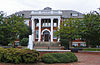 | December 6, 1991 (#91001779) | 200 W. Main St. 35°59′36″N 79°56′21″W / 35.993333°N 79.939167°W / 35.993333; -79.939167 (Former Jamestown High School) | Jamestown | |
| 28 | Former Charles D. McIver School |  | April 3, 1992 (#92000177) | 643 W. Gate City Boulevard 36°03′47″N 79°48′04″W / 36.063056°N 79.801111°W / 36.063056; -79.801111 (Former Charles D. McIver School) | Greensboro | Currently used as a church. |
| 29 | Former Pomona High School |  | February 24, 1995 (#92001888) | 2021 Spring Garden St. 36°03′47″N 79°49′48″W / 36.063056°N 79.830000°W / 36.063056; -79.830000 (Former Pomona High School) | Greensboro | |
| 30 | Former L. Richardson Memorial Hospital |  | April 3, 1992 (#92000180) | 603 S. Benbow Rd. 36°04′04″N 79°46′14″W / 36.067778°N 79.770556°W / 36.067778; -79.770556 (Former L. Richardson Memorial Hospital) | Greensboro | |
| 31 | Edward J. Forney House |  | April 21, 1992 (#92000359) | 1402 Spring Garden St. 36°03′56″N 79°48′48″W / 36.065556°N 79.813333°W / 36.065556; -79.813333 (Edward J. Forney House) | Greensboro | |
| 32 | Daniel P. Foust House | Upload image | January 20, 2005 (#04001522) | 439 Brightwood Church Rd. 36°04′40″N 79°34′48″W / 36.077778°N 79.58°W / 36.077778; -79.58 (Daniel P. Foust House) | Whitsett | |
| 33 | Julius I. Foust Building |  | September 11, 1980 (#80002838) | 1000 W. Spring Garden St. 36°04′01″N 79°48′29″W / 36.066944°N 79.808056°W / 36.066944; -79.808056 (Julius I. Foust Building) | Greensboro | |
| 34 | Foust-Carpenter and Dean Dick Farms | Upload image | July 1, 2009 (#09000504) | East and west sides of Mt. Hope Church Rd. and north and south sides of Carpenter House Rd. 36°01′26″N 79°37′53″W / 36.023889°N 79.631389°W / 36.023889; -79.631389 (Foust-Carpenter and Dean Dick Farms) | Whitsett | |
| 35 | John Marion Galloway House |  | July 21, 1983 (#83001886) | 1007 N. Elm St. 36°05′11″N 79°47′24″W / 36.086389°N 79.79°W / 36.086389; -79.79 (John Marion Galloway House) | Greensboro | |
| 36 | Gardner House | Upload image | October 15, 1974 (#74001350) | East of Jamestown on SR 1383 35°59′19″N 79°53′28″W / 35.988611°N 79.891111°W / 35.988611; -79.891111 (Gardner House) | Jamestown | |
| 37 | Gibsonville School | 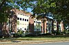 | August 18, 2014 (#14000495) | 500 Church St. 36°06′33″N 79°32′39″W / 36.109167°N 79.544167°W / 36.109167; -79.544167 (Gibsonville School) | Gibsonville | |
| 38 | Dr. C. S. Grayson House | 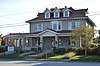 | March 17, 1994 (#94000190) | 1009 N. Main St. 35°58′06″N 80°00′54″W / 35.968333°N 80.015000°W / 35.968333; -80.015000 (Dr. C. S. Grayson House) | High Point | |
| 39 | Green Hill Cemetery Gatekeeper's House |  | May 29, 1979 (#79001713) | 700 Battleground Ave. 36°04′47″N 79°47′43″W / 36.079722°N 79.795278°W / 36.079722; -79.795278 (Green Hill Cemetery Gatekeeper's House) | Greensboro | |
| 40 | Greensboro Historical Museum | 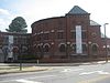 | April 25, 1985 (#85000877) | 130 Summit Ave. 36°04′32″N 79°47′17″W / 36.075556°N 79.788056°W / 36.075556; -79.788056 (Greensboro Historical Museum) | Greensboro | |
| 41 | Greensboro Senior High School |  | September 7, 2005 (#05000957) | 801 Westover Terrace 36°05′02″N 79°48′57″W / 36.083889°N 79.815833°W / 36.083889; -79.815833 (Greensboro Senior High School) | Greensboro | |
| 42 | Guilford College |  | June 21, 1990 (#90000855) | 5800 W. Friendly Ave. 36°05′40″N 79°52′58″W / 36.094444°N 79.882778°W / 36.094444; -79.882778 (Guilford College) | Greensboro | |
| 43 | Guilford County Courthouse |  | May 10, 1979 (#79001714) | Market St. 36°04′20″N 79°47′34″W / 36.072222°N 79.792778°W / 36.072222; -79.792778 (Guilford County Courthouse) | Greensboro | |
| 44 | Guilford County Office and Court Building |  | December 20, 1988 (#88002843) | 258 S. Main St. 35°57′14″N 80°00′20″W / 35.953889°N 80.005556°W / 35.953889; -80.005556 (Guilford County Office and Court Building) | High Point | |
| 45 | Guilford Courthouse National Military Park |  | October 15, 1966 (#66000069) | Address Restricted | Greensboro | |
| 46 | Guilford Mill |  | August 2, 1982 (#82003462) | Southeast of Oak Ridge on NC 68 36°09′38″N 79°58′41″W / 36.160556°N 79.978056°W / 36.160556; -79.978056 (Guilford Mill) | Oak Ridge | |
| 47 | John Haley House |  | August 26, 1971 (#71000587) | 1805 E. Lexington Ave. 35°58′49″N 79°59′42″W / 35.980278°N 79.995°W / 35.980278; -79.995 (John Haley House) | High Point | |
| 48 | Hardee Apartments |  | March 14, 1991 (#91000260) | 1102 N. Main St. 35°58′10″N 80°00′53″W / 35.969306°N 80.014722°W / 35.969306; -80.014722 (Hardee Apartments) | High Point | |
| 49 | Highland Cotton Mills Village Historic District | 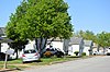 | May 23, 2014 (#14000263) | Roughly bounded by W. Market Center Dr., Connor, Jordan & Young Pls., S. Elm St. 35°56′10″N 80°00′43″W / 35.9360°N 80.0120°W / 35.9360; -80.0120 (Highland Cotton Mills Village Historic District) | High Point | |
| 50 | Hillsdale Brick Store | Upload image | June 14, 1982 (#82003459) | NC 150 and SR 2347 36°12′00″N 79°50′39″W / 36.199997°N 79.844092°W / 36.199997; -79.844092 (Hillsdale Brick Store) | Hillsdale | |
| 51 | Hillside | 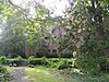 | February 1, 1980 (#80002839) | 301 Fisher Park Circle 36°04′32″N 79°47′34″W / 36.075556°N 79.792778°W / 36.075556; -79.792778 (Hillside) | Greensboro | |
| 52 | Holly Gate | Upload image | September 22, 1980 (#80002840) | NC 61 36°04′18″N 79°33′50″W / 36.071667°N 79.563889°W / 36.071667; -79.563889 (Holly Gate) | Whitsett | |
| 53 | Hoskins House Historic District |  | March 15, 1988 (#88000175) | Intersection of New Garden Rd. and US 220 36°08′19″N 79°51′10″W / 36.138611°N 79.852778°W / 36.138611; -79.852778 (Hoskins House Historic District) | Greensboro | |
| 54 | Charles H. Ireland House |  | May 29, 1979 (#79001715) | 602 W. Friendly Ave. 36°04′26″N 79°47′51″W / 36.073889°N 79.7975°W / 36.073889; -79.7975 (Charles H. Ireland House) | Greensboro | Destroyed by fire February 2, 1996 |
| 55 | Irving Park Historic District |  | February 21, 1995 (#94001050) | Roughly bounded by Buffalo Cr., Battleground Ave., Cornwallis Dr. and W. Northwood St. 36°05′47″N 79°47′54″W / 36.096389°N 79.798333°W / 36.096389; -79.798333 (Irving Park Historic District) | Greensboro | |
| 56 | Jamestown Historic District | Upload image | January 22, 1973 (#73001345) | Both sides of U.S. 29A 35°59′40″N 79°56′44″W / 35.994444°N 79.945556°W / 35.994444; -79.945556 (Jamestown Historic District) | Jamestown | |
| 57 | Allen Jay School Rock Gymnasium |  | August 28, 2012 (#12000574) | 1201 E. Fairfield Rd. 35°55′33″N 79°57′38″W / 35.925904°N 79.960644°W / 35.925904; -79.960644 (Allen Jay School Rock Gymnasium) | High Point | |
| 58 | Jefferson Standard Building |  | May 28, 1976 (#76001326) | Elm and Market Sts. 36°04′22″N 79°47′32″W / 36.072778°N 79.792222°W / 36.072778; -79.792222 (Jefferson Standard Building) | Greensboro | |
| 59 | Kellenberger Estate | Upload image | March 17, 1994 (#94000218) | 1415 Kellenberger Rd. 36°03′13″N 79°40′19″W / 36.053611°N 79.671944°W / 36.053611; -79.671944 (Kellenberger Estate) | Greensboro | |
| 60 | Kilby Hotel | 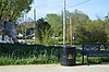 | April 22, 1982 (#82003460) | 627 E. Washington St. 35°57′40″N 80°00′02″W / 35.961111°N 80.000556°W / 35.961111; -80.000556 (Kilby Hotel) | High Point | |
| 61 | Kimrey-Haworth House | 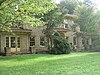 | March 14, 1991 (#91000265) | 5307 W. Friendly Ave. 36°05′20″N 79°52′43″W / 36.088889°N 79.878611°W / 36.088889; -79.878611 (Kimrey-Haworth House) | Greensboro | |
| 62 | O. Arthur Kirkman House and Outbuildings |  | January 28, 1988 (#87002567) | 501 W. High St.; also 106 Oak St. 35°57′13″N 80°00′42″W / 35.9536°N 80.0117°W / 35.9536; -80.0117 (O. Arthur Kirkman House and Outbuildings) | High Point | 106 Oak represents a boundary increase of June 9, 1989 |
| 63 | Latham-Baker House |  | November 12, 1982 (#82001298) | 412 Fisher Park Circle 36°04′56″N 79°47′30″W / 36.0822°N 79.7917°W / 36.0822; -79.7917 (Latham-Baker House) | Greensboro | |
| 64 | Low House | Upload image | March 8, 1978 (#78001957) | South of Gibsonville 36°02′59″N 79°34′13″W / 36.0497°N 79.5703°W / 36.0497; -79.5703 (Low House) | Whitsett | |
| 65 | Lyndon Street Townhouses | 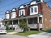 | April 3, 1992 (#92000178) | 195-201 Lyndon St. 36°04′16″N 79°47′07″W / 36.0711°N 79.7853°W / 36.0711; -79.7853 (Lyndon Street Townhouses) | Greensboro | |
| 66 | Harden Thomas Martin House |  | December 19, 1985 (#85003217) | 204 N. Mendenhall St. 36°04′28″N 79°48′09″W / 36.0744°N 79.8025°W / 36.0744; -79.8025 (Harden Thomas Martin House) | Greensboro | |
| 67 | McCulloch's Gold Mill | 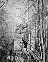 | April 24, 1979 (#79001717) | Address Restricted | Jamestown | |
| 68 | Dr. Joseph A. McLean House |  | February 2, 1995 (#94001632) | US 70 north side, 0.1 miles (0.16 km) west of junction with SR 3053 36°04′15″N 79°37′54″W / 36.0708°N 79.6317°W / 36.0708; -79.6317 (Dr. Joseph A. McLean House) | Sedalia | |
| 69 | Melrose Hosiery Mill No. 1 | Upload image | November 3, 2020 (#100005749) | 1533-1547 West English Rd., 105-109 SW Point Ave. 35°56′55″N 80°01′08″W / 35.9486°N 80.0188°W / 35.9486; -80.0188 (Melrose Hosiery Mill No. 1) | High Point | |
| 70 | Richard Mendenhall Plantation Buildings |  | November 3, 1972 (#72000964) | U.S. Route 29 35°59′34″N 79°56′56″W / 35.9928°N 79.9489°W / 35.9928; -79.9489 (Richard Mendenhall Plantation Buildings) | Jamestown | |
| 71 | Minneola Manufacturing Company Cloth Warehouse | 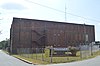 | September 11, 2018 (#100002928) | 108 E. Railroad Ave. 36°06′16″N 79°32′30″W / 36.1044°N 79.5417°W / 36.1044; -79.5417 (Minneola Manufacturing Company Cloth Warehouse) | Gibsonville | |
| 72 | Minneola Manufacturing Company Mill | Upload image | December 21, 2023 (#100009628) | 106 Railroad Avenue 36°06′21″N 79°32′38″W / 36.1058°N 79.5438°W / 36.1058; -79.5438 (Minneola Manufacturing Company Mill) | Gibsonville | |
| 73 | Mock, Judson, Voehringer Company Hosiery Mill |  | March 28, 2011 (#11000141) | 2610 Oakland Ave. 36°03′43″N 79°50′07″W / 36.0619°N 79.8353°W / 36.0619; -79.8353 (Mock, Judson, Voehringer Company Hosiery Mill) | Greensboro | Textile mill built between 1927 and 1938[6] |
| 74 | Model Farm | Upload image | April 20, 2011 (#11000208) | 2058 Brentwood St. 35°56′17″N 79°58′42″W / 35.9381°N 79.9783°W / 35.9381; -79.9783 (Model Farm) | High Point | |
| 75 | Oak Ridge Military Academy Historic District | 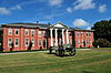 | March 17, 1983 (#83001887) | NC 150 and NC 68 36°10′32″N 79°59′13″W / 36.1756°N 79.9869°W / 36.1756; -79.9869 (Oak Ridge Military Academy Historic District) | Oak Ridge | |
| 76 | Oakdale Cotton Mill Village |  | March 15, 1976 (#76001327) | SR 1352 and SR 1144 35°58′50″N 79°55′48″W / 35.9806°N 79.93°W / 35.9806; -79.93 (Oakdale Cotton Mill Village) | Jamestown | |
| 77 | Oakwood Historic District |  | February 7, 1991 (#90002197) | 100-300 blocks Oakwood St. 35°57′22″N 80°00′48″W / 35.9561°N 80.0133°W / 35.9561; -80.0133 (Oakwood Historic District) | High Point | |
| 78 | One Plaza Center | Upload image | April 10, 2024 (#100010204) | 101 S. Main Street 35°57′26″N 80°00′20″W / 35.9572°N 80.0055°W / 35.9572; -80.0055 (One Plaza Center) | High Point | |
| 79 | Palmer Memorial Institute Historic District | Upload image | October 24, 1988 (#88002029) | Along US 70 west of the junction with NC 3056 36°04′02″N 79°37′25″W / 36.0672°N 79.6236°W / 36.0672; -79.6236 (Palmer Memorial Institute Historic District) | Sedalia | |
| 80 | William Penn High School |  | November 16, 1978 (#78001959) | Washington Dr. 35°57′43″N 79°59′51″W / 35.9619°N 79.9975°W / 35.9619; -79.9975 (William Penn High School) | High Point | |
| 81 | Pickett Cotton Mills |  | September 1, 2015 (#15000558) | 1200 Redding Dr. 35°56′34″N 80°01′00″W / 35.9429°N 80.0168°W / 35.9429; -80.0168 (Pickett Cotton Mills) | High Point | |
| 82 | Pilot Life Insurance Company Home Office | Upload image | July 27, 2022 (#100007970) | 5300 High Point Rd. 36°01′22″N 79°53′05″W / 36.0229°N 79.8846°W / 36.0229; -79.8846 (Pilot Life Insurance Company Home Office) | Greensboro | |
| 83 | Proximity Print Works |  | December 1, 2014 (#14000986) | 1700 Fairview St. 36°06′04″N 79°46′20″W / 36.1012°N 79.7723°W / 36.1012; -79.7723 (Proximity Print Works) | Greensboro | |
| 84 | Ragsdale Farm | Upload image | September 3, 1991 (#91001171) | 404 E. Main St. 35°59′48″N 79°55′51″W / 35.9967°N 79.9308°W / 35.9967; -79.9308 (Ragsdale Farm) | Jamestown | |
| 85 | Revolution Cotton Mills |  | March 1, 1984 (#84002324) | Roughly bounded by Southern RR, N. Buffalo Creek, Yanceyville and 9th Sts. 36°05′57″N 79°46′42″W / 36.0992°N 79.7783°W / 36.0992; -79.7783 (Revolution Cotton Mills) | Greensboro | |
| 86 | Thomas Scott House | Upload image | July 12, 1984 (#84002328) | SR 1001 36°10′06″N 79°47′28″W / 36.168333°N 79.791111°W / 36.168333; -79.791111 (Thomas Scott House) | Greensboro | |
| 87 | Shaw-Cude House | Upload image | June 1, 1982 (#82003455) | Off SR 2010 36°07′26″N 79°59′00″W / 36.123889°N 79.983333°W / 36.123889; -79.983333 (Shaw-Cude House) | Colfax | |
| 88 | Sherrod Park | Upload image | March 14, 1991 (#91000278) | 200-300 blocks Woodrow Ave. 35°58′08″N 80°00′28″W / 35.968889°N 80.007778°W / 35.968889; -80.007778 (Sherrod Park) | High Point | |
| 89 | Michael Sherwood House | 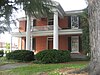 | January 31, 1978 (#78001958) | 426 W. Friendly Ave. 36°04′26″N 79°47′43″W / 36.073889°N 79.795278°W / 36.073889; -79.795278 (Michael Sherwood House) | Greensboro | |
| 90 | J. C. Siceloff House |  | March 14, 1991 (#91000264) | 1104 N. Main St. 35°58′10″N 80°00′54″W / 35.969444°N 80.015000°W / 35.969444; -80.015000 (J. C. Siceloff House) | High Point | |
| 91 | Francis Marion Smith House |  | July 12, 1984 (#84002330) | 204 Railroad Ave. 36°06′15″N 79°32′28″W / 36.104167°N 79.541111°W / 36.104167; -79.541111 (Francis Marion Smith House) | Gibsonville | |
| 92 | William Rankin and Elizabeth Wharton Smith House | Upload image | February 27, 2007 (#07000091) | 437 Brightwood Church Rd., NC 2758, 0.62 miles (1.00 km) north of US 70 36°04′44″N 79°34′51″W / 36.078889°N 79.580833°W / 36.078889; -79.580833 (William Rankin and Elizabeth Wharton Smith House) | Whitsett | |
| 93 | South Greensboro Historic District |  | December 20, 1991 (#91001812) | Roughly bounded by Gorrell, Martin, E. Bragg, Sevier, Omaha, Broad, Caldwell, Andrew, Vance, McCulloch, and King Dr. 36°03′40″N 79°47′06″W / 36.061111°N 79.785°W / 36.061111; -79.785 (South Greensboro Historic District) | Greensboro | |
| 94 | Sigmund Sternberger House | 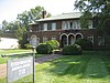 | April 16, 1993 (#93000302) | 712 Summit Ave. 36°04′52″N 79°46′44″W / 36.081111°N 79.778889°W / 36.081111; -79.778889 (Sigmund Sternberger House) | Greensboro | |
| 95 | Summerfield Historic District | Upload image | May 18, 2005 (#05000437) | 4105-4210 Oak Ridge Rd. and 7702-7804 Summerfield Rd. 36°12′25″N 79°54′21″W / 36.206944°N 79.905833°W / 36.206944; -79.905833 (Summerfield Historic District) | Summerfield | |
| 96 | Summerfield School Gymnasium and Community Center | Upload image | August 28, 2012 (#12000575) | 7515 Trainer Dr. 36°12′01″N 79°54′18″W / 36.2002°N 79.905068°W / 36.2002; -79.905068 (Summerfield School Gymnasium and Community Center) | Summerfield | |
| 97 | Summit Avenue Historic District |  | August 5, 1993 (#93000768) | Roughly bounded by Chestnut, E. Bessemer, Cypress, Dewey, Park, and Percy Sts. 36°04′54″N 79°46′55″W / 36.081667°N 79.781944°W / 36.081667; -79.781944 (Summit Avenue Historic District) | Greensboro | |
| 98 | Sunset Hills Historic District |  | January 17, 2013 (#12001179) | Bounded by W. Friendly, N. & S. Elam & W. Wright Aves., S. Tremont Dr., N. Aycock St. & Kensington Rd. 36°04′24″N 79°49′16″W / 36.073222°N 79.821111°W / 36.073222; -79.821111 (Sunset Hills Historic District) | Greensboro | |
| 99 | Tabernacle Methodist Protestant Church and Cemetery |  | March 10, 1995 (#95000231) | 5601 Liberty Rd. 35°57′55″N 79°41′49″W / 35.965278°N 79.696944°W / 35.965278; -79.696944 (Tabernacle Methodist Protestant Church and Cemetery) | Greensboro | |
| 100 | A. E. Taplin Apartment Building |  | March 1, 1996 (#96000196) | 408 W. Parkway Ave. 35°58′03″N 80°01′11″W / 35.967500°N 80.019722°W / 35.967500; -80.019722 (A. E. Taplin Apartment Building) | High Point | |
| 101 | Tomlinson Chair Manufacturing Company Complex | 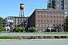 | March 17, 1983 (#83001888) | 305 W. High St. 35°57′18″N 80°00′33″W / 35.955000°N 80.009167°W / 35.955000; -80.009167 (Tomlinson Chair Manufacturing Company Complex) | High Point | |
| 102 | Union Cemetery | 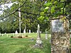 | October 21, 1993 (#93001142) | 900 blook S. Elm St. 36°03′31″N 79°47′29″W / 36.058611°N 79.791389°W / 36.058611; -79.791389 (Union Cemetery) | Greensboro | |
| 103 | United States Post Office and Court House |  | October 29, 2014 (#14000886) | 324 W. Market St. 36°04′24″N 79°47′37″W / 36.0732°N 79.7936°W / 36.0732; -79.7936 (United States Post Office and Court House) | Greensboro | |
| 104 | Uptown Suburbs Historic District |  | January 9, 2013 (#12001158) | Roughly bounded by W. Lexington & Sunset Aves., Westchester Dr., Johnson & W. Ray Sts. 35°58′09″N 80°01′23″W / 35.969046°N 80.023087°W / 35.969046; -80.023087 (Uptown Suburbs Historic District) | High Point | |
| 105 | Wadsworth Congregational Church | Upload image | December 31, 2002 (#02001659) | 1301 Rock Creek Dairy Rd. 36°02′49″N 79°35′52″W / 36.046944°N 79.597778°W / 36.046944; -79.597778 (Wadsworth Congregational Church) | Whitsett | |
| 106 | Wafco Mills |  | May 30, 1979 (#79001716) | 801 McGee St. 36°04′07″N 79°47′56″W / 36.068611°N 79.798889°W / 36.068611; -79.798889 (Wafco Mills) | Greensboro | |
| 107 | Simeon Wagoner House |  | September 3, 1991 (#91001172) | 5838 NC 61 (Friedens Church Rd.) 36°07′31″N 79°33′31″W / 36.125278°N 79.558611°W / 36.125278; -79.558611 (Simeon Wagoner House) | Gibsonville | |
| 108 | Washington Street Historic District |  | December 28, 2010 (#10001094) | Portions of eight blocks on Washington, Centennial, Fourth, and Hobson Sts., Eccles Pl., and Gaylord Ct. 35°57′40″N 80°00′08″W / 35.961111°N 80.002222°W / 35.961111; -80.002222 (Washington Street Historic District) | High Point | |
| 109 | Dr. David P. Weir House |  | July 12, 1984 (#84002332) | 223 N. Edgeworth St. 36°04′28″N 79°47′48″W / 36.074444°N 79.796667°W / 36.074444; -79.796667 (Dr. David P. Weir House) | Greensboro | |
| 110 | West High Street Historic District |  | April 12, 2007 (#07000295) | 407, 409, 415, 501, 503, and 507 W. High St., and 106, 107, and 110 Oak St. 35°57′20″N 80°00′41″W / 35.955556°N 80.011389°W / 35.955556; -80.011389 (West High Street Historic District) | High Point | |
| 111 | West Market Street Methodist Episcopal Church, South |  | December 19, 1985 (#85003198) | 302 W. Market St. 36°04′25″N 79°47′36″W / 36.073611°N 79.793333°W / 36.073611; -79.793333 (West Market Street Methodist Episcopal Church, South) | Greensboro | |
| 112 | White Oak New Town Historic District |  | April 3, 1992 (#92000176) | 2400-2418 N. Church, 2312-2509 Spruce, 2310-2503 Hubbard and 2401-2503 Cypress Sts. 36°06′23″N 79°46′45″W / 36.106389°N 79.779167°W / 36.106389; -79.779167 (White Oak New Town Historic District) | Greensboro | |
| 113 | Whitsett Historic District | Upload image | May 5, 1999 (#99000532) | Junction NC 61 and NC 3064 36°04′06″N 79°33′49″W / 36.068333°N 79.563611°W / 36.068333; -79.563611 (Whitsett Historic District) | Whitsett | |
| 114 | James H. and Anne B. Willis House |  | April 23, 2015 (#15000181) | 707 Blair St. 36°05′38″N 79°48′13″W / 36.0938°N 79.8036°W / 36.0938; -79.8036 (James H. and Anne B. Willis House) | Greensboro | |
| 115 | Lucy and J. Vassie Wilson House |  | May 4, 2005 (#05000378) | 425 Hillcrest Dr. 35°58′19″N 80°01′38″W / 35.971944°N 80.027222°W / 35.971944; -80.027222 (Lucy and J. Vassie Wilson House) | High Point | |
| 116 | World War Memorial Stadium |  | April 12, 2001 (#01000377) | 510 Yanceyville St. 36°04′47″N 79°46′38″W / 36.0797°N 79.7772°W / 36.0797; -79.7772 (World War Memorial Stadium) | Greensboro |
Former listing
| [3] | Name on the Register | Image | Date listed | Date removed | Location | City or town | Description |
|---|---|---|---|---|---|---|---|
| 1 | Founders Hall | Upload image | 1973 (#73002237) | 1974 | 55800 W Friendly Ave. | Greensboro | Demolished in 1973 |
See also
Wikimedia Commons has media related to National Register of Historic Places in Guilford County, North Carolina.
- National Register of Historic Places listings in North Carolina
- List of National Historic Landmarks in North Carolina
References
- ^ The latitude and longitude information provided in this table was derived originally from the National Register Information System, which has been found to be fairly accurate for about 99% of listings. Some locations in this table may have been corrected to current GPS standards.
- ^ National Park Service, United States Department of the Interior, "National Register of Historic Places: Weekly List Actions", retrieved July 12, 2024.
- ^ a b Numbers represent an alphabetical ordering by significant words. Various colorings, defined here, differentiate National Historic Landmarks and historic districts from other NRHP buildings, structures, sites or objects.
- ^ "National Register Information System". National Register of Historic Places. National Park Service. April 24, 2008.
- ^ The eight-digit number below each date is the number assigned to each location in the National Register Information System database, which can be viewed by clicking the number.
- ^ "MoJud Mill Considered For Mixed-Use Preservation Project". Greensboro, North Carolina: Preservation Greensboro. May 18, 2010. Retrieved April 14, 2011.
- v
- t
- e

by county
- Alamance
- Alexander
- Alleghany
- Anson
- Ashe
- Avery
- Beaufort
- Bertie
- Bladen
- Brunswick
- Buncombe
- Burke
- Cabarrus
- Caldwell
- Camden
- Carteret
- Caswell
- Catawba
- Chatham
- Cherokee
- Chowan
- Clay
- Cleveland
- Columbus
- Craven
- Cumberland
- Currituck
- Dare
- Davidson
- Davie
- Duplin
- Durham
- Edgecombe
- Forsyth
- Franklin
- Gaston
- Gates
- Graham
- Granville
- Greene
- Guilford
- Halifax
- Harnett
- Haywood
- Henderson
- Hertford
- Hoke
- Hyde
- Iredell
- Jackson
- Johnston
- Jones
- Lee
- Lenoir
- Lincoln
- Macon
- Madison
- Martin
- McDowell
- Mecklenburg
- Mitchell
- Montgomery
- Moore
- Nash
- New Hanover
- Northampton
- Onslow
- Orange
- Pamlico
- Pasquotank
- Pender
- Perquimans
- Person
- Pitt
- Polk
- Randolph
- Richmond
- Robeson
- Rockingham
- Rowan
- Rutherford
- Sampson
- Scotland
- Stanly
- Stokes
- Surry
- Swain
- Transylvania
- Tyrrell
- Union
- Vance
- Wake
- Warren
- Washington
- Watauga
- Wayne
- Wilkes
- Wilson
- Yadkin
- Yancey
| |
|---|---|
| Topics | |
| Lists by state |
|
| Lists by insular areas | |
| Lists by associated state | |
| Other areas | |
| Related | |
| |