National Register of Historic Places listings in Franklin County, North Carolina
Map all coordinates using OpenStreetMap
Download coordinates as:
- KML
- GPX (all coordinates)
- GPX (primary coordinates)
- GPX (secondary coordinates)

This list includes properties and districts listed on the National Register of Historic Places in Franklin County, North Carolina. Click the "Map of all coordinates" link to the right to view an online map of all properties and districts with latitude and longitude coordinates in the table below.[1]
Current listings
This National Park Service list is complete through NPS recent listings posted July 12, 2024.[2]
| [3] | Name on the Register[4] | Image | Date listed[5] | Location | City or town | Description |
|---|---|---|---|---|---|---|
| 1 | Andrews-Moore House |  | December 10, 1998 (#98001506) | 95 Simon Collie Rd. 36°00′09″N 78°11′14″W / 36.0025°N 78.187222°W / 36.0025; -78.187222 (Andrews-Moore House) | Bunn | House burned on March 29, 2006, causing significant damage, but was able to be repaired. |
| 2 | Baker Farm | Upload image | October 5, 1982 (#82001297) | SW of Bunn on SR 1720 35°56′59″N 78°18′50″W / 35.949722°N 78.313889°W / 35.949722; -78.313889 (Baker Farm) | Bunn | |
| 3 | Cascine |  | April 26, 1973 (#73001342) | S of Louisburg on SR 1702; also the northern side of NC 1702 36°02′21″N 78°19′25″W / 36.039167°N 78.323611°W / 36.039167; -78.323611 (Cascine) | Louisburg | Second set of boundaries represents a boundary increase of December 4, 1985 |
| 4 | Clifton House and Mill Site | Upload image | April 17, 1980 (#80002835) | SR 1103 36°00′05″N 78°21′00″W / 36.001389°N 78.35°W / 36.001389; -78.35 (Clifton House and Mill Site) | Royal | |
| 5 | Concord School |  | May 31, 2018 (#100002517) | 645 Walter Grissom Rd. 36°09′47″N 78°22′46″W / 36.1631°N 78.3794°W / 36.1631; -78.3794 (Concord School) | Kittrell | |
| 5 | Cooke House | Upload image | October 14, 1975 (#75001265) | SW of Louisburg near jct. of SR 1114 and SR 1109 36°03′19″N 78°20′23″W / 36.055278°N 78.339722°W / 36.055278; -78.339722 (Cooke House) | Louisburg | |
| 6 | Archibald H. Davis Plantation | Upload image | July 24, 1975 (#75001266) | SE of Louisburg off NC 581 36°03′12″N 78°11′45″W / 36.053333°N 78.195833°W / 36.053333; -78.195833 (Archibald H. Davis Plantation) | Justice | |
| 7 | Dean Farm | Upload image | May 2, 1975 (#75001267) | 6 miles E of Louisburg on NC 56 36°05′21″N 78°10′46″W / 36.089167°N 78.179444°W / 36.089167; -78.179444 (Dean Farm) | Louisburg | |
| 8 | Franklin County Training School-Riverside Union School | 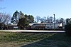 | January 4, 2012 (#11001011) | 53 W. River Rd. 36°05′40″N 78°18′21″W / 36.094444°N 78.305833°W / 36.094444; -78.305833 (Franklin County Training School-Riverside Union School) | Louisburg | |
| 9 | Franklinton Depot |  | December 27, 1990 (#90001941) | 201 E. Mason St. 36°06′11″N 78°27′20″W / 36.103056°N 78.455556°W / 36.103056; -78.455556 (Franklinton Depot) | Franklinton | |
| 10 | Fuller House |  | November 17, 1978 (#78001954) | 307 N. Main St. 36°06′13″N 78°17′58″W / 36.103611°N 78.299444°W / 36.103611; -78.299444 (Fuller House) | Louisburg | |
| 11 | Green Hill House |  | June 10, 1975 (#75001268) | S of Louisburg near jct. of SR 1760 and 1761 36°04′51″N 78°18′19″W / 36.080833°N 78.305278°W / 36.080833; -78.305278 (Green Hill House) | Louisburg | |
| 12 | Dr. J. H. Harris House |  | August 1, 1975 (#75001260) | 312 E. Mason St. 36°06′15″N 78°27′04″W / 36.104167°N 78.451111°W / 36.104167; -78.451111 (Dr. J. H. Harris House) | Franklinton | |
| 13 | William A. Jeffreys House | Upload image | June 23, 1976 (#76001323) | SE of Youngsville on SR 1101 35°57′22″N 78°23′41″W / 35.956111°N 78.394722°W / 35.956111; -78.394722 (William A. Jeffreys House) | Youngsville | |
| 14 | Jones-Wright House | Upload image | March 12, 1992 (#92000149) | NC 1003 W side, 0.2 miles S of jct. with NC 1252 36°12′44″N 78°20′54″W / 36.212222°N 78.348333°W / 36.212222; -78.348333 (Jones-Wright House) | Rocky Ford | |
| 15 | Shemuel Kearney House | 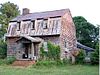 | June 5, 1975 (#75001261) | 1 miles S of Franklinton on U.S. 1 36°04′36″N 78°28′53″W / 36.076667°N 78.481389°W / 36.076667; -78.481389 (Shemuel Kearney House) | Franklinton | House was moved to Louisburg in 2009. |
| 16 | Laurel Mill and Col. Jordan Jones House | 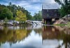 | May 30, 1975 (#75001262) | SW of Gupton at jct. of SR 1432 and 1436 36°10′40″N 78°11′30″W / 36.177778°N 78.191667°W / 36.177778; -78.191667 (Laurel Mill and Col. Jordan Jones House) | Gupton | |
| 17 | Locust Grove | Upload image | November 20, 1975 (#75001269) | N of Louisburg on U.S. 401 36°10′31″N 78°17′26″W / 36.175278°N 78.290556°W / 36.175278; -78.290556 (Locust Grove) | Ingleside | |
| 18 | Louisburg Historic District |  | February 18, 1987 (#87000041) | Roughly bounded by Allen Lane, Main and Cedar Sts., Franklin, Elm, and King St. 36°06′12″N 78°17′57″W / 36.103333°N 78.299167°W / 36.103333; -78.299167 (Louisburg Historic District) | Louisburg | |
| 19 | Main Building, Louisburg College |  | December 8, 1978 (#78001955) | Louisburg College campus 36°06′17″N 78°18′00″W / 36.104722°N 78.3°W / 36.104722; -78.3 (Main Building, Louisburg College) | Louisburg | |
| 20 | Massenburg Plantation | Upload image | July 30, 1975 (#75001270) | Address Restricted; also 821 NC 561 36°07′06″N 78°16′08″W / 36.118333°N 78.268889°W / 36.118333; -78.268889 (Massenburg Plantation) | Louisburg | 821 NC 561 represents a boundary increase of March 15, 2000 |
| 21 | C.L. and Bessie G. McGhee House |  | September 5, 2007 (#07000903) | 103 W. Mason St. 36°06′14″N 78°27′33″W / 36.103889°N 78.459167°W / 36.103889; -78.459167 (C.L. and Bessie G. McGhee House) | Franklinton | |
| 22 | Monreath | Upload image | August 6, 1975 (#75001264) | S of Ingleside on NC 39 36°10′00″N 78°17′34″W / 36.166667°N 78.292778°W / 36.166667; -78.292778 (Monreath) | Ingleside | |
| 23 | Pearce-Stallings-Massey House | Upload image | December 30, 2020 (#100005997) | 4430 Old US 64 35°52′48″N 78°16′17″W / 35.8801°N 78.2714°W / 35.8801; -78.2714 (Pearce-Stallings-Massey House) | Pilot vicinity | |
| 23 | Dr. Samuel Perry House |  | June 5, 1975 (#75001263) | East of Gupton on SR 1436 36°11′52″N 78°09′06″W / 36.197778°N 78.151667°W / 36.197778; -78.151667 (Dr. Samuel Perry House) | Gupton | |
| 24 | Perry School | Upload image | January 3, 2011 (#10001110) | 2266 Laurel Mill-Centerville Rd. 36°11′35″N 78°07′28″W / 36.193056°N 78.124444°W / 36.193056; -78.124444 (Perry School) | Centerville | |
| 25 | Person Place |  | June 19, 1972 (#72000962) | 603 N. Main St. 36°06′22″N 78°17′46″W / 36.106139°N 78.296231°W / 36.106139; -78.296231 (Person Place) | Louisburg | |
| 26 | Person-McGhee Farm |  | June 26, 1979 (#79003343) | US 1 36°09′36″N 78°27′11″W / 36.16°N 78.453056°W / 36.16; -78.453056 (Person-McGhee Farm) | Franklinton | |
| 27 | Portridge |  | March 1, 1990 (#90000351) | SR 1224, 0.3 miles N of jct. with NC 56 36°05′25″N 78°21′04″W / 36.090278°N 78.351111°W / 36.090278; -78.351111 (Portridge) | Louisburg | |
| 28 | Rose Hill | Upload image | May 3, 2006 (#06000339) | W side of US 401 S, 0.25 miles N of NC 1110 36°04′15″N 78°19′54″W / 36.070833°N 78.331667°W / 36.070833; -78.331667 (Rose Hill) | Louisburg | |
| 29 | Dr. J. A. Savage House | Upload image | September 22, 1980 (#80002834) | 124 College St. 36°05′56″N 78°27′27″W / 36.098944°N 78.457500°W / 36.098944; -78.457500 (Dr. J. A. Savage House) | Franklinton | House was demolished in 1997. |
| 30 | Speed Farm | Upload image | December 27, 1991 (#91001907) | W side NC 1436 between NC 1432 and NC 1434 36°11′17″N 78°11′26″W / 36.188056°N 78.190556°W / 36.188056; -78.190556 (Speed Farm) | Gupton | |
| 31 | Sterling Cotton Mill |  | May 16, 1996 (#96000568) | SE jct. of Seabord RR tracks and E. Green St. 36°05′59″N 78°27′25″W / 36.099722°N 78.456944°W / 36.099722; -78.456944 (Sterling Cotton Mill) | Franklinton | |
| 32 | Archibald Taylor House | Upload image | May 12, 1975 (#75001273) | Address Restricted | Wood | |
| 33 | Patty Person Taylor House |  | February 13, 1975 (#75001271) | Address Restricted | Louisburg | |
| 34 | Aldridge H. Vann House |  | January 9, 2008 (#07001373) | 115 N Main St. 36°06′20″N 78°27′23″W / 36.105556°N 78.456389°W / 36.105556; -78.456389 (Aldridge H. Vann House) | Franklinton | |
| 35 | Vine Hill | Upload image | May 28, 1975 (#75001259) | Address Restricted | Centerville | |
| 36 | Thomas and Lois Wheless House |  | August 28, 2007 (#07000887) | 106 John St. 36°06′01″N 78°17′44″W / 36.100278°N 78.295556°W / 36.100278; -78.295556 (Thomas and Lois Wheless House) | Louisburg | |
| 37 | Williamson House |  | June 20, 1975 (#75001272) | 401 Cedar St. 36°06′03″N 78°17′45″W / 36.100833°N 78.295833°W / 36.100833; -78.295833 (Williamson House) | Louisburg |
See also
Wikimedia Commons has media related to National Register of Historic Places in Franklin County, North Carolina.
- National Register of Historic Places listings in North Carolina
- List of National Historic Landmarks in North Carolina
References
- ^ The latitude and longitude information provided in this table was derived originally from the National Register Information System, which has been found to be fairly accurate for about 99% of listings. Some locations in this table may have been corrected to current GPS standards.
- ^ National Park Service, United States Department of the Interior, "National Register of Historic Places: Weekly List Actions", retrieved July 12, 2024.
- ^ Numbers represent an alphabetical ordering by significant words. Various colorings, defined here, differentiate National Historic Landmarks and historic districts from other NRHP buildings, structures, sites or objects.
- ^ "National Register Information System". National Register of Historic Places. National Park Service. April 24, 2008.
- ^ The eight-digit number below each date is the number assigned to each location in the National Register Information System database, which can be viewed by clicking the number.
- v
- t
- e

by county
- Alamance
- Alexander
- Alleghany
- Anson
- Ashe
- Avery
- Beaufort
- Bertie
- Bladen
- Brunswick
- Buncombe
- Burke
- Cabarrus
- Caldwell
- Camden
- Carteret
- Caswell
- Catawba
- Chatham
- Cherokee
- Chowan
- Clay
- Cleveland
- Columbus
- Craven
- Cumberland
- Currituck
- Dare
- Davidson
- Davie
- Duplin
- Durham
- Edgecombe
- Forsyth
- Franklin
- Gaston
- Gates
- Graham
- Granville
- Greene
- Guilford
- Halifax
- Harnett
- Haywood
- Henderson
- Hertford
- Hoke
- Hyde
- Iredell
- Jackson
- Johnston
- Jones
- Lee
- Lenoir
- Lincoln
- Macon
- Madison
- Martin
- McDowell
- Mecklenburg
- Mitchell
- Montgomery
- Moore
- Nash
- New Hanover
- Northampton
- Onslow
- Orange
- Pamlico
- Pasquotank
- Pender
- Perquimans
- Person
- Pitt
- Polk
- Randolph
- Richmond
- Robeson
- Rockingham
- Rowan
- Rutherford
- Sampson
- Scotland
- Stanly
- Stokes
- Surry
- Swain
- Transylvania
- Tyrrell
- Union
- Vance
- Wake
- Warren
- Washington
- Watauga
- Wayne
- Wilkes
- Wilson
- Yadkin
- Yancey
| |
|---|---|
| Topics | |
| Lists by state |
|
| Lists by insular areas | |
| Lists by associated state | |
| Other areas | |
| Related | |
| |


