National Register of Historic Places listings in Macon County, North Carolina
Map all coordinates using OpenStreetMap
Download coordinates as:
- KML
- GPX (all coordinates)
- GPX (primary coordinates)
- GPX (secondary coordinates)

This list includes properties and districts listed on the National Register of Historic Places in Macon County, North Carolina. Click the "Map of all coordinates" link to the right to view a Google map of all properties and districts with latitude and longitude coordinates in the table below.[1]
Current listings
This National Park Service list is complete through NPS recent listings posted July 12, 2024.[2]
| [3] | Name on the Register[4] | Image | Date listed[5] | Location | City or town | Description |
|---|---|---|---|---|---|---|
| 1 | Baldwin-Coker Cottage |  | May 9, 2003 (#03000390) | 226 Lower Lake Rd. 35°03′19″N 83°11′13″W / 35.055278°N 83.186944°W / 35.055278; -83.186944 (Baldwin-Coker Cottage) | Highlands | |
| 2 | Dr. Alexander C. Brabson House | Upload image | August 23, 1990 (#90001312) | SR 1118, 0.6 mile S. of jct. with SR 1115 35°04′45″N 83°23′54″W / 35.079149°N 83.39830°W / 35.079149; -83.39830 (Dr. Alexander C. Brabson House) | Otto | |
| 3 | Albert Swain Bryson House |  | December 20, 1984 (#84000541) | Pine Lane 35°11′02″N 83°22′35″W / 35.183889°N 83.376389°W / 35.183889; -83.376389 (Albert Swain Bryson House) | Franklin | |
| 4 | Cabin Ben | 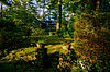 | April 22, 2003 (#03000299) | 115 Cullasaja Dr. 35°03′50″N 83°12′36″W / 35.063889°N 83.21°W / 35.063889; -83.21 (Cabin Ben) | Highlands | |
| 5 | Church of the Incarnation |  | May 16, 1996 (#96000566) | 111 N. 5th St. 35°03′07″N 83°11′45″W / 35.051944°N 83.195833°W / 35.051944; -83.195833 (Church of the Incarnation) | Highlands | |
| 6 | Cowee Mound and Village Site |  | January 18, 1973 (#73002238) | Address Restricted 35°15′55″N 83°25′03″W / 35.2652°N 83.4174°W / 35.2652; -83.4174 (Cowee Mound and Village Site) | West's Mill | |
| 7 | Cowee-West's Mill Historic District |  | January 8, 2001 (#00001569) | Address Restricted 35°15′45″N 83°24′33″W / 35.262500°N 83.409167°W / 35.262500; -83.409167 (Cowee-West's Mill Historic District) | Franklin | |
| 8 | Edwards Hotel |  | November 20, 1992 (#92001614) | Jct. of Main and Fourth Sts., SE corner 35°03′07″N 83°11′50″W / 35.051944°N 83.197222°W / 35.051944; -83.197222 (Edwards Hotel) | Highlands | |
| 9 | First Presbyterian Church |  | August 22, 1996 (#96000925) | 471 Main St. 35°03′06″N 83°11′48″W / 35.051667°N 83.196667°W / 35.051667; -83.196667 (First Presbyterian Church) | Highlands | |
| 10 | Franklin Presbyterian Church | 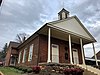 | February 5, 1987 (#86003718) | 45 Church St. 35°10′57″N 83°23′02″W / 35.1825°N 83.383889°W / 35.1825; -83.383889 (Franklin Presbyterian Church) | Franklin | |
| 11 | Franklin Terrace Hotel |  | July 29, 1982 (#82003483) | 67 Harrison Ave. 35°11′01″N 83°23′02″W / 35.183611°N 83.383889°W / 35.183611; -83.383889 (Franklin Terrace Hotel) | Franklin | |
| 12 | Glen Choga Lodge | Upload image | April 23, 1996 (#96000538) | 50 Lodge Rd. 35°11′27″N 83°40′50″W / 35.190833°N 83.680556°W / 35.190833; -83.680556 (Glen Choga Lodge) | Aquone | |
| 13 | Thomas Grant Harbison House | Upload image | April 30, 2008 (#08000368) | 2930 Walhalla Rd. 35°01′45″N 83°11′33″W / 35.029139°N 83.192472°W / 35.029139; -83.192472 (Thomas Grant Harbison House) | Highlands | |
| 14 | Highlands Inn | 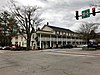 | December 18, 1990 (#90001916) | Jct. of Main and Fourth Sts. 35°03′10″N 83°11′48″W / 35.052778°N 83.196667°W / 35.052778; -83.196667 (Highlands Inn) | Highlands | |
| 15 | Highlands North Historic District |  | July 28, 2011 (#11000482) | 608-650,507-615 Hickory St., 760-856,827 N. 5th St., 23-29,425 Brock Ct.,802,850-854 N. 4th St., 29 Martha's Ln. 35°03′30″N 83°11′40″W / 35.058333°N 83.194444°W / 35.058333; -83.194444 (Highlands North Historic District) | Highlands | |
| 16 | Nequasee |  | November 26, 1980 (#80004598) | Main St.[6] 35°11′06″N 83°22′25″W / 35.185000°N 83.373611°W / 35.185000; -83.373611 (Nequasee) | Franklin | Site 31MA1[7] |
| 17 | Pendergrass Building | 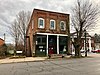 | September 26, 1991 (#91001469) | 6 W. Main St. 35°10′47″N 83°22′53″W / 35.179722°N 83.381389°W / 35.179722; -83.381389 (Pendergrass Building) | Franklin | |
| 18 | Playmore-Bowery Road Historic District | Upload image | March 27, 2002 (#01001071) | 1309-1311 Horse Cove Rd., 7,215,225,369,455 and 172-176,200,462 Bowery Rd., and 375-471 Upper Lake Rd. 35°03′14″N 83°10′37″W / 35.053839°N 83.176953°W / 35.053839; -83.176953 (Playmore-Bowery Road Historic District) | Highlands | |
| 19 | Elizabeth Wright Prince House |  | April 17, 2017 (#100000901) | 524 N. 4th St. 35°03′19″N 83°11′50″W / 35.055345°N 83.197236°W / 35.055345; -83.197236 (Elizabeth Wright Prince House) | Highlands | |
| 20 | Saint Agnes Church |  | June 4, 1987 (#87000822) | 27 Church St. 35°10′59″N 83°22′58″W / 35.183056°N 83.382778°W / 35.183056; -83.382778 (Saint Agnes Church) | Franklin | |
| 21 | Salem Methodist Church | Upload image | May 8, 2013 (#13000247) | 1201 River Rd. 35°08′57″N 83°18′55″W / 35.149041°N 83.315203°W / 35.149041; -83.315203 (Salem Methodist Church) | Franklin | |
| 22 | Satulah Mountain Historic District | Upload image | October 5, 1995 (#95001155) | Roughly bounded by NC 28, Satulah, Brooks, Worley, Warren, and Old Walhalla Rd. 35°02′33″N 83°11′52″W / 35.0425°N 83.197778°W / 35.0425; -83.197778 (Satulah Mountain Historic District) | Highlands | |
| 23 | Jesse R. Siler House |  | April 29, 1982 (#82003484) | 115 W. Main St. 35°10′51″N 83°23′10″W / 35.180833°N 83.386111°W / 35.180833; -83.386111 (Jesse R. Siler House) | Franklin | |
| 24 | Skyline Lodge | Upload image | April 13, 2022 (#100007591) | 470 Skyline Lodge Rd. 35°04′36″N 83°12′45″W / 35.0767°N 83.2125°W / 35.0767; -83.2125 (Skyline Lodge) | Highlands vicinity | |
| 25 | Wilson Log House | Upload image | May 20, 1998 (#98000545) | NC 1621, 1.4 miles northwest of its junction with NC 1620 35°02′44″N 83°16′23″W / 35.045460°N 83.273165°W / 35.045460; -83.273165 (Wilson Log House) | Highlands |
See also
Wikimedia Commons has media related to National Register of Historic Places in Macon County, North Carolina.
- National Register of Historic Places listings in North Carolina
- List of National Historic Landmarks in North Carolina
References
- ^ The latitude and longitude information provided in this table was derived originally from the National Register Information System, which has been found to be fairly accurate for about 99% of listings. Some locations in this table may have been corrected to current GPS standards.
- ^ National Park Service, United States Department of the Interior, "National Register of Historic Places: Weekly List Actions", retrieved July 12, 2024.
- ^ Numbers represent an alphabetical ordering by significant words. Various colorings, defined here, differentiate National Historic Landmarks and historic districts from other NRHP buildings, structures, sites or objects.
- ^ "National Register Information System". National Register of Historic Places. National Park Service. April 24, 2008.
- ^ The eight-digit number below each date is the number assigned to each location in the National Register Information System database, which can be viewed by clicking the number.
- ^ Master Site Record, Research Laboratories of Archaeology, University of North Carolina at Chapel Hill, n.d. Accessed 2014-06-23.
- ^ "National Register Information System". National Register of Historic Places. National Park Service. July 9, 2010.
- v
- t
- e

by county
- Alamance
- Alexander
- Alleghany
- Anson
- Ashe
- Avery
- Beaufort
- Bertie
- Bladen
- Brunswick
- Buncombe
- Burke
- Cabarrus
- Caldwell
- Camden
- Carteret
- Caswell
- Catawba
- Chatham
- Cherokee
- Chowan
- Clay
- Cleveland
- Columbus
- Craven
- Cumberland
- Currituck
- Dare
- Davidson
- Davie
- Duplin
- Durham
- Edgecombe
- Forsyth
- Franklin
- Gaston
- Gates
- Graham
- Granville
- Greene
- Guilford
- Halifax
- Harnett
- Haywood
- Henderson
- Hertford
- Hoke
- Hyde
- Iredell
- Jackson
- Johnston
- Jones
- Lee
- Lenoir
- Lincoln
- Macon
- Madison
- Martin
- McDowell
- Mecklenburg
- Mitchell
- Montgomery
- Moore
- Nash
- New Hanover
- Northampton
- Onslow
- Orange
- Pamlico
- Pasquotank
- Pender
- Perquimans
- Person
- Pitt
- Polk
- Randolph
- Richmond
- Robeson
- Rockingham
- Rowan
- Rutherford
- Sampson
- Scotland
- Stanly
- Stokes
- Surry
- Swain
- Transylvania
- Tyrrell
- Union
- Vance
- Wake
- Warren
- Washington
- Watauga
- Wayne
- Wilkes
- Wilson
- Yadkin
- Yancey
| |
|---|---|
| Topics | |
| Lists by state |
|
| Lists by insular areas | |
| Lists by associated state | |
| Other areas | |
| Related | |
| |


Municipalities and communities of Macon County, North Carolina, United States | ||
|---|---|---|
County seat: Franklin | ||
| Towns |  | |
| Unincorporated communities | ||
| Footnotes | ‡This populated place also has portions in an adjacent county or counties | |
| ||


