National Register of Historic Places listings in Duplin County, North Carolina
Map all coordinates using OpenStreetMap
Download coordinates as:
- KML
- GPX (all coordinates)
- GPX (primary coordinates)
- GPX (secondary coordinates)

This list includes properties and districts listed on the National Register of Historic Places in Duplin County, North Carolina. Click the "Map of all coordinates" link to the right to view a Google map of all properties and districts with latitude and longitude coordinates in the table below.[1]
Current listings
This National Park Service list is complete through NPS recent listings posted July 12, 2024.[2]
| [3] | Name on the Register | Image | Date listed[4] | Location | City or town | Description |
|---|---|---|---|---|---|---|
| 1 | Joshua James Blanchard House |  | August 28, 2012 (#12000572) | 415 Carrolls Rd. 34°58′31″N 78°09′03″W / 34.975316°N 78.150925°W / 34.975316; -78.150925 (Joshua James Blanchard House) | Warsaw | |
| 2 | W. Stokes Boney House | Upload image | July 8, 1999 (#99000812) | 651 E. Southerland St. 34°44′31″N 77°59′09″W / 34.741944°N 77.985833°W / 34.741944; -77.985833 (W. Stokes Boney House) | Wallace | |
| 3 | Carter-Simmons House | 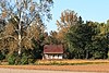 | April 15, 2015 (#15000162) | 218 Coy Smith Rd. 35°05′48″N 77°48′27″W / 35.0966°N 77.8074°W / 35.0966; -77.8074 (Carter-Simmons House) | Albertson | |
| 4 | Roger Dickson Farm | Upload image | February 8, 1988 (#88000053) | E side of SR 1917 34°51′42″N 78°00′28″W / 34.861667°N 78.007778°W / 34.861667; -78.007778 (Roger Dickson Farm) | Magnolia | |
| 5 | Faison Cemetery | 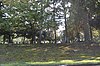 | April 19, 2006 (#06000291) | East Main St. (NC 403) 35°06′59″N 78°07′54″W / 35.116389°N 78.131667°W / 35.116389; -78.131667 (Faison Cemetery) | Faison | |
| 6 | Faison Historic District | 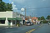 | January 2, 1997 (#96001550) | Roughly bounded by College, Hill, Solomon, and Ellis Sts. 35°07′00″N 78°08′16″W / 35.116667°N 78.137778°W / 35.116667; -78.137778 (Faison Historic District) | Faison | |
| 7 | William Wright Faison House | Upload image | December 23, 2004 (#04001390) | NC 1304, 0.2 miles (0.32 km) southeast of the junction with NC 1354 35°04′51″N 78°03′35″W / 35.080833°N 78.059722°W / 35.080833; -78.059722 (William Wright Faison House) | Bowdens | |
| 8 | B. F. Grady School | Upload image | February 24, 1994 (#94000085) | North side NC 11, 0.3 miles (0.48 km) west of the junction with NC 111 35°03′20″N 77°49′54″W / 35.055556°N 77.831667°W / 35.055556; -77.831667 (B. F. Grady School) | Kornegay | Destroyed April 1996[5] |
| 9 | Hebron Presbyterian Church | Upload image | February 24, 1995 (#95000144) | NC 1551 northwest side, 0.15 miles (0.24 km) northeast of the junction with NC 1554 35°03′44″N 77°46′57″W / 35.062222°N 77.7825°W / 35.062222; -77.7825 (Hebron Presbyterian Church) | Pink Hill | |
| 10 | Bryan Whitfield Herring Farm | Upload image | November 29, 2001 (#01001315) | NC 1311, 1 mile (1.6 km) east of the junction with NC 1302 35°09′57″N 78°07′37″W / 35.165833°N 78.126944°W / 35.165833; -78.126944 (Bryan Whitfield Herring Farm) | Calypso | |
| 11 | Needham Whitfield Herring House | Upload image | May 26, 1994 (#94000529) | 201 NC 24-50 34°57′28″N 77°58′51″W / 34.957778°N 77.980833°W / 34.957778; -77.980833 (Needham Whitfield Herring House) | Kenansville | |
| 12 | Buckner Hill House | Upload image | December 6, 1975 (#75001255) | Southeast of Faison on SR 1354 35°05′00″N 78°05′13″W / 35.083333°N 78.086944°W / 35.083333; -78.086944 (Buckner Hill House) | Faison | |
| 13 | Kenansville Historic District |  | March 13, 1975 (#75001256) | Downtown area centered around Main St. and Limestone Rd. as far N as Hill St. 34°57′38″N 77°57′47″W / 34.960556°N 77.963056°W / 34.960556; -77.963056 (Kenansville Historic District) | Kenansville | |
| 14 | Loftin Farm | Upload image | December 31, 2001 (#01001426) | NC 1368, 0.65 miles (1.05 km) south of the junction with NC 1367 35°09′15″N 78°01′28″W / 35.154167°N 78.024444°W / 35.154167; -78.024444 (Loftin Farm) | Beautancus | |
| 15 | John Wesley Mallard House |  | December 23, 2004 (#04001391) | NC 1301, 0.25 miles (0.40 km) south of NC 1329 35°06′36″N 78°08′56″W / 35.110000°N 78.148889°W / 35.110000; -78.148889 (John Wesley Mallard House) | Faison | |
| 16 | Isaac M. Powers House | Upload image | April 15, 1999 (#99000461) | NC 1154, 0.8 miles (1.3 km) south of the junction of NC 1154 and NC 4 34°44′01″N 78°02′01″W / 34.733611°N 78.033611°W / 34.733611; -78.033611 (Isaac M. Powers House) | Wallace | |
| 17 | Wallace Commercial Historic District | Upload image | October 20, 1995 (#95001179) | Roughly bounded by Southerland, College, Boney and Raleigh Sts. 34°44′08″N 77°59′35″W / 34.735556°N 77.993056°W / 34.735556; -77.993056 (Wallace Commercial Historic District) | Wallace | |
| 18 | Warsaw Historic District | 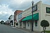 | December 13, 1996 (#96001484) | Roughly bounded by former Atlantic Coastline RR right-of-way, N. and S. Front, Pollock, Frisco, Plank, and Railroad Sts. 34°59′58″N 78°05′37″W / 34.999444°N 78.093611°W / 34.999444; -78.093611 (Warsaw Historic District) | Warsaw | |
| 19 | Waterloo | Upload image | January 8, 1975 (#75001254) | 2 miles (3.2 km) south of Albertson on NC 111 35°05′12″N 77°48′55″W / 35.086667°N 77.815278°W / 35.086667; -77.815278 (Waterloo) | Albertson |
See also
Wikimedia Commons has media related to National Register of Historic Places in Duplin County, North Carolina.
- National Register of Historic Places listings in North Carolina
- List of National Historic Landmarks in North Carolina
References
- ^ The latitude and longitude information provided in this table was derived originally from the National Register Information System, which has been found to be fairly accurate for about 99% of listings. Some locations in this table may have been corrected to current GPS standards.
- ^ National Park Service, United States Department of the Interior, "National Register of Historic Places: Weekly List Actions", retrieved July 12, 2024.
- ^ Numbers represent an alphabetical ordering by significant words. Various colorings, defined here, differentiate National Historic Landmarks and historic districts from other NRHP buildings, structures, sites or objects.
- ^ The eight-digit number below each date is the number assigned to each location in the National Register Information System database, which can be viewed by clicking the number.
- ^ "North Carolina Listings in the National Register of Historic Places by County". North Carolina State Historic Preservation Office. 22 October 2008. Archived from the original on 30 November 2012. Retrieved 14 July 2009.
- v
- t
- e

by county
- Alamance
- Alexander
- Alleghany
- Anson
- Ashe
- Avery
- Beaufort
- Bertie
- Bladen
- Brunswick
- Buncombe
- Burke
- Cabarrus
- Caldwell
- Camden
- Carteret
- Caswell
- Catawba
- Chatham
- Cherokee
- Chowan
- Clay
- Cleveland
- Columbus
- Craven
- Cumberland
- Currituck
- Dare
- Davidson
- Davie
- Duplin
- Durham
- Edgecombe
- Forsyth
- Franklin
- Gaston
- Gates
- Graham
- Granville
- Greene
- Guilford
- Halifax
- Harnett
- Haywood
- Henderson
- Hertford
- Hoke
- Hyde
- Iredell
- Jackson
- Johnston
- Jones
- Lee
- Lenoir
- Lincoln
- Macon
- Madison
- Martin
- McDowell
- Mecklenburg
- Mitchell
- Montgomery
- Moore
- Nash
- New Hanover
- Northampton
- Onslow
- Orange
- Pamlico
- Pasquotank
- Pender
- Perquimans
- Person
- Pitt
- Polk
- Randolph
- Richmond
- Robeson
- Rockingham
- Rowan
- Rutherford
- Sampson
- Scotland
- Stanly
- Stokes
- Surry
- Swain
- Transylvania
- Tyrrell
- Union
- Vance
- Wake
- Warren
- Washington
- Watauga
- Wayne
- Wilkes
- Wilson
- Yadkin
- Yancey
| |
|---|---|
| Topics | |
| Lists by state |
|
| Lists by insular areas | |
| Lists by associated state | |
| Other areas | |
| Related | |
| |


