National Register of Historic Places listings in Cumberland County, North Carolina

Map all coordinates using OpenStreetMap
Download coordinates as:
- KML
- GPX (all coordinates)
- GPX (primary coordinates)
- GPX (secondary coordinates)
This list includes properties and districts listed on the National Register of Historic Places in Cumberland County, North Carolina, United States. Click the "Map of all coordinates" link to the right to view a Google map of all properties and districts with latitude and longitude coordinates in the table below.[1]
Current listings
This National Park Service list is complete through NPS recent listings posted July 12, 2024.[2]
| [3] | Name on the Register[4] | Image | Date listed[5] | Location | City or town | Description |
|---|---|---|---|---|---|---|
| 1 | Atlantic Coast Line Railroad Station |  | July 7, 1982 (#82001294) | 472 Hay St. 35°03′18″N 78°53′05″W / 35.055°N 78.884722°W / 35.055; -78.884722 (Atlantic Coast Line Railroad Station) | Fayetteville | |
| 2 | Barge's Tavern |  | July 7, 1983 (#83001843) | 519 Ramsey St. 35°03′39″N 78°52′42″W / 35.060833°N 78.878333°W / 35.060833; -78.878333 (Barge's Tavern) | Fayetteville | |
| 3 | Belden-Horne House |  | March 16, 1972 (#72000955) | 519 Ramsey St. 35°03′39″N 78°52′42″W / 35.060833°N 78.878333°W / 35.060833; -78.878333 (Belden-Horne House) | Fayetteville | |
| 4 | Big Rockfish Presbyterian Church |  | July 21, 1983 (#83001844) | SR 2268 34°57′06″N 78°55′27″W / 34.951667°N 78.924167°W / 34.951667; -78.924167 (Big Rockfish Presbyterian Church) | Hope Mills | |
| 5 | Brownlea |  | August 21, 2003 (#03000803) | 405 Southampton Court 35°03′08″N 78°54′53″W / 35.052222°N 78.914722°W / 35.052222; -78.914722 (Brownlea) | Fayetteville | |
| 6 | Camp Ground Methodist Church |  | July 7, 1983 (#83001845) | Camp Ground Rd. 35°04′04″N 78°58′22″W / 35.067778°N 78.972778°W / 35.067778; -78.972778 (Camp Ground Methodist Church) | Fayetteville | |
| 7 | Cape Fear and Yadkin Valley Railway Passenger Depot |  | July 7, 1983 (#83001846) | 148 Maxwell St. 35°03′08″N 78°52′56″W / 35.052222°N 78.882222°W / 35.052222; -78.882222 (Cape Fear and Yadkin Valley Railway Passenger Depot) | Fayetteville | |
| 8 | Cape Fear Baptist Church |  | October 13, 1983 (#83003816) | SR 2233 34°54′21″N 78°49′37″W / 34.905833°N 78.826944°W / 34.905833; -78.826944 (Cape Fear Baptist Church) | Grays Creek | |
| 9 | The Capitol |  | May 4, 2005 (#05000376) | 126 Hay St. 35°03′18″N 78°52′45″W / 35.055°N 78.879167°W / 35.055; -78.879167 (The Capitol) | Fayetteville | |
| 10 | Carolina Theater |  | July 7, 1983 (#83001847) | 443 Hay St. 35°03′15″N 78°53′01″W / 35.054167°N 78.883611°W / 35.054167; -78.883611 (Carolina Theater) | Fayetteville | Destroyed[6] |
| 11 | Confederate Breastworks |  | October 7, 1981 (#81000421) | 2300 Ramsey St. 35°05′19″N 78°52′34″W / 35.088688°N 78.87613°W / 35.088688; -78.87613 (Confederate Breastworks) | Fayetteville | |
| 12 | Cool Spring Place |  | October 10, 1972 (#72000956) | 119 N. Cool Spring St. 35°03′08″N 78°52′30″W / 35.052222°N 78.875°W / 35.052222; -78.875 (Cool Spring Place) | Fayetteville | |
| 13 | Cool Springs | Upload image | September 19, 1985 (#85002417) | Off SR 1607 at Cumberland 35°14′02″N 78°52′29″W / 35.233889°N 78.874722°W / 35.233889; -78.874722 (Cool Springs) | Carvers Creek | |
| 14 | Cross Creek Cemetery Number One |  | September 25, 1998 (#98001209) | Junction of N. Cool Spring and Grove St. 35°03′17″N 78°52′23″W / 35.054722°N 78.873056°W / 35.054722; -78.873056 (Cross Creek Cemetery Number One) | Fayetteville | Also see Cross Creek Cemetery |
| 15 | Cumberland County Courthouse |  | May 10, 1979 (#79001696) | Franklin, Gillespie, and Russell Sts. 35°03′05″N 78°52′45″W / 35.051389°N 78.879167°W / 35.051389; -78.879167 (Cumberland County Courthouse) | Fayetteville | part of the North Carolina County Courthouses Thematic Resource |
| 16 | John Davis House |  | July 7, 1983 (#83001848) | 910 Arsenal Ave. 35°03′18″N 78°53′45″W / 35.055000°N 78.895833°W / 35.055000; -78.895833 (John Davis House) | Fayetteville | |
| 17 | Devane-MacQueen House | Upload image | July 21, 1983 (#83001849) | NC 87 34°52′50″N 78°50′33″W / 34.880556°N 78.8425°W / 34.880556; -78.8425 (Devane-MacQueen House) | Grays Creek | |
| 18 | Ellerslie | Upload image | August 7, 1974 (#74001344) | West of Linden on SR 1607 at the junction with SR 1606 35°13′50″N 78°52′31″W / 35.230556°N 78.875278°W / 35.230556; -78.875278 (Ellerslie) | Linden | |
| 19 | Evans Metropolitan AME Zion Church | 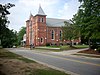 | July 7, 1983 (#83001850) | 301 N. Cool Spring St. 35°03′12″N 78°52′53″W / 35.053333°N 78.881389°W / 35.053333; -78.881389 (Evans Metropolitan AME Zion Church) | Fayetteville | |
| 20 | Falcon Tabernacle |  | October 11, 1983 (#83003814) | West St. 35°11′37″N 78°38′52″W / 35.193611°N 78.647778°W / 35.193611; -78.647778 (Falcon Tabernacle) | Falcon | |
| 21 | Fayetteville Downtown Historic District |  | July 1, 1999 (#99000779) | Roughly along Hay, Person, Green, Gillespie, Bow, Old, W. Russell and Cool Spring Sts. 35°03′11″N 78°52′41″W / 35.053056°N 78.878056°W / 35.053056; -78.878056 (Fayetteville Downtown Historic District) | Fayetteville | |
| 22 | Fayetteville Ice and Manufacturing Company:Plant and Engineer's House | Upload image | July 7, 1983 (#83001851) | 436 Rowan St. and 438 Rowan St. 35°03′36″N 78°53′00″W / 35.06°N 78.883333°W / 35.06; -78.883333 (Fayetteville Ice and Manufacturing Company:Plant and Engineer's House) | Fayetteville | |
| 23 | Fayetteville Mutual Insurance Company Building |  | July 7, 1983 (#83001852) | 320 Hay St. 35°03′14″N 78°52′54″W / 35.053889°N 78.881667°W / 35.053889; -78.881667 (Fayetteville Mutual Insurance Company Building) | Fayetteville | |
| 24 | Fayetteville Veterans Administration Hospital Historic District |  | September 19, 2012 (#12000799) | 2300 Ramsey St. 35°05′19″N 78°52′34″W / 35.088688°N 78.87613°W / 35.088688; -78.87613 (Fayetteville Veterans Administration Hospital Historic District) | Fayetteville | |
| 25 | Fayetteville Women's Club and Oval Ballroom | 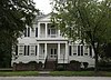 | February 6, 1973 (#73001330) | 224 Dick St. 35°02′53″N 78°52′42″W / 35.048056°N 78.878333°W / 35.048056; -78.878333 (Fayetteville Women's Club and Oval Ballroom) | Fayetteville | Fayetteville Women's Club is also known as Sandford House |
| 26 | First Baptist Church |  | July 7, 1983 (#83001853) | 200 Old St. 35°03′14″N 78°52′47″W / 35.053889°N 78.879722°W / 35.053889; -78.879722 (First Baptist Church) | Fayetteville | |
| 27 | First Presbyterian Church |  | April 30, 1976 (#76001317) | Ann and Bow Sts. 35°03′12″N 78°52′32″W / 35.053333°N 78.875556°W / 35.053333; -78.875556 (First Presbyterian Church) | Fayetteville | |
| 28 | Gully Mill | Upload image | July 7, 1983 (#83001854) | S.R. 1839 35°03′22″N 78°50′29″W / 35.056111°N 78.841389°W / 35.056111; -78.841389 (Gully Mill) | Fayetteville | |
| 29 | Hangars 4 and 5, Pope Air Force Base | Upload image | January 16, 1991 (#90002153) | Bldg. 708, Pope AFB 35°10′40″N 79°00′52″W / 35.177778°N 79.014444°W / 35.177778; -79.014444 (Hangars 4 and 5, Pope Air Force Base) | Fayetteville | |
| 30 | Hay Street Methodist Church |  | July 7, 1983 (#83001855) | Hay St. at Ray and Old Sts. 35°03′11″N 78°52′27″W / 35.053056°N 78.874167°W / 35.053056; -78.874167 (Hay Street Methodist Church) | Fayetteville | |
| 31 | Haymount District |  | August 7, 1983 (#83001856) | Roughly Hillside Ave. from Bragg Boulevard to Purshing St. • Boundary increase (listed April 10, 2007, refnum 07000296): 100-200 blocks of Bradford Ave., 801 Hay St., and 801, 802, and 806 Arsenal Ave. 35°03′24″N 78°53′22″W / 35.056667°N 78.889444°W / 35.056667; -78.889444 (Haymount District) | Fayetteville | |
| 32 | Holt-Harrison House |  | July 7, 1983 (#83001857) | 806 Hay St. 35°03′22″N 78°53′33″W / 35.056111°N 78.8925°W / 35.056111; -78.8925 (Holt-Harrison House) | Fayetteville | |
| 33 | Hope Mills Historic District |  | July 9, 1985 (#85001515) | Roughly bounded by Seaboard Coastline RR tracks, Lakeview Rd., Little Creek and Cross St. 34°58′17″N 78°56′43″W / 34.971389°N 78.945278°W / 34.971389; -78.945278 (Hope Mills Historic District) | Hope Mills | |
| 34 | Kyle House | 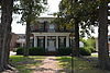 | June 19, 1972 (#72000957) | 234 Green St. 35°03′21″N 78°52′36″W / 35.055833°N 78.876667°W / 35.055833; -78.876667 (Kyle House) | Fayetteville | |
| 35 | Liberty Row | | August 14, 1973 (#73001331) | N Side of the first block of Person St., bounded by Market Sq. and Liberty Point 35°03′08″N 78°52′39″W / 35.052222°N 78.8775°W / 35.052222; -78.8775 (Liberty Row) | Fayetteville | |
| 36 | Long Valley Farm | Upload image | June 6, 1994 (#94000032) | Carvers Creek State Park Coordinates missing | Spring Lake | |
| 37 | M & O Chevrolet Company | 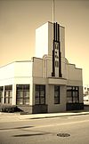 | July 7, 1983 (#83001858) | 412 W. Russell St. 35°03′11″N 78°53′05″W / 35.053056°N 78.884722°W / 35.053056; -78.884722 (M & O Chevrolet Company) | Fayetteville | |
| 38 | Mansard Roof House | 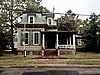 | March 20, 1973 (#73001332) | 214 Mason St. 35°03′21″N 78°52′45″W / 35.055833°N 78.879167°W / 35.055833; -78.879167 (Mansard Roof House) | Fayetteville | |
| 39 | Market House |  | September 15, 1970 (#70000451) | Market Sq. 35°03′10″N 78°52′40″W / 35.052778°N 78.877778°W / 35.052778; -78.877778 (Market House) | Fayetteville | |
| 40 | Market House Square District | 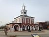 | July 7, 1983 (#83001860) | Hay, Person, Green, and Gillespie Sts. 35°03′09″N 78°52′44″W / 35.0525°N 78.878889°W / 35.0525; -78.878889 (Market House Square District) | Fayetteville | |
| 41 | Massey Hill High School |  | December 23, 2004 (#04001387) | 1062 Southern Ave. 35°01′51″N 78°53′40″W / 35.030861°N 78.894325°W / 35.030861; -78.894325 (Massey Hill High School) | Fayetteville | |
| 42 | Maxwell House | 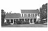 | February 28, 1985 (#85000380) | Off NC 24 35°01′18″N 78°43′23″W / 35.021667°N 78.723056°W / 35.021667; -78.723056 (Maxwell House) | Stedman | |
| 43 | McArthur-Council House | Upload image | July 21, 1983 (#83001861) | SR 2244 34°53′38″N 78°55′58″W / 34.893889°N 78.932778°W / 34.893889; -78.932778 (McArthur-Council House) | Grays Creek | |
| 44 | McCall House | 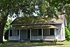 | July 7, 1983 (#83001862) | 822 Arsenal Ave. 35°03′18″N 78°53′39″W / 35.055°N 78.894167°W / 35.055; -78.894167 (McCall House) | Fayetteville | |
| 45 | William McDiarmid House |  | July 7, 1983 (#83001863) | 330 Dick St. 35°02′51″N 78°52′45″W / 35.0475°N 78.879167°W / 35.0475; -78.879167 (William McDiarmid House) | Fayetteville | |
| 46 | Henry McLean House |  | July 7, 1983 (#83001864) | 1006 Hay St. 35°03′24″N 78°53′49″W / 35.056667°N 78.896944°W / 35.056667; -78.896944 (Henry McLean House) | Fayetteville | |
| 47 | Nimocks House |  | January 20, 1972 (#72000958) | 225 Dick St. 35°03′01″N 78°52′34″W / 35.050278°N 78.876111°W / 35.050278; -78.876111 (Nimocks House) | Fayetteville | |
| 48 | North Carolina Arsenal Site |  | February 23, 1983 (#83001865) | Arsenal Park, behind the Museum of the Cape Fear Historical Complex 35°03′14″N 78°53′41″W / 35.054°N 78.8947°W / 35.054; -78.8947 (North Carolina Arsenal Site) | Fayetteville | Remains of a US (and later Confederate) Army arsenal |
| 49 | Oak Grove | Upload image | February 6, 1973 (#73001329) | South of Erwin near the junction of NC 82 and SR 1875 35°15′00″N 78°41′25″W / 35.25°N 78.690278°W / 35.25; -78.690278 (Oak Grove) | Erwin | |
| 50 | John A. Oates House | Upload image | July 7, 1983 (#83001866) | 406 St. James Sq. 35°03′26″N 78°52′35″W / 35.057222°N 78.876389°W / 35.057222; -78.876389 (John A. Oates House) | Fayetteville | |
| 51 | Old Bluff Presbyterian Church |  | August 7, 1974 (#74001345) | North of Wade on SR 1709 35°11′02″N 78°43′25″W / 35.183889°N 78.723611°W / 35.183889; -78.723611 (Old Bluff Presbyterian Church) | Wade | |
| 52 | Orange Street School |  | September 22, 1987 (#87001597) | 500 block of Orange St., at the junction of Orange and Chance Sts. 35°03′50″N 78°52′49″W / 35.063889°N 78.880278°W / 35.063889; -78.880278 (Orange Street School) | Fayetteville | |
| 53 | John E. Patterson House |  | July 7, 1983 (#83001867) | 445 Moore St. 35°03′42″N 78°53′01″W / 35.061667°N 78.883611°W / 35.061667; -78.883611 (John E. Patterson House) | Fayetteville | |
| 54 | Phoenix Masonic Lodge No. 8 |  | July 7, 1983 (#83001868) | 221 Mason St. 35°03′21″N 78°52′48″W / 35.055833°N 78.88°W / 35.055833; -78.88 (Phoenix Masonic Lodge No. 8) | Fayetteville | |
| 55 | Edgar Allan Poe House |  | July 7, 1983 (#83001869) | 206 Bradford Ave. 35°03′14″N 78°52′47″W / 35.053889°N 78.879722°W / 35.053889; -78.879722 (Edgar Allan Poe House) | Fayetteville | |
| 56 | Pope Air Force Base Historic District | Upload image | January 25, 1991 (#90002152) | Bldgs. 300, 302, 306, and Old Family Housing Units 35°10′13″N 79°00′13″W / 35.170278°N 79.003611°W / 35.170278; -79.003611 (Pope Air Force Base Historic District) | Fayetteville | |
| 57 | Prince Charles Hotel |  | July 7, 1983 (#83001870) | 430 Hay St. 35°03′16″N 78°53′00″W / 35.054444°N 78.883333°W / 35.054444; -78.883333 (Prince Charles Hotel) | Fayetteville | built 1925; also known as Hotel Prince Charles;[7] |
| 58 | Sedberry-Holmes House |  | September 2, 1975 (#75001252) | 232 Person St. 35°03′04″N 78°52′33″W / 35.051111°N 78.875833°W / 35.051111; -78.875833 (Sedberry-Holmes House) | Fayetteville | |
| 59 | Seventy-First Consolidated School |  | December 23, 2004 (#04001388) | 6830 Raeford Rd. 35°02′17″N 79°00′34″W / 35.038056°N 79.009444°W / 35.038056; -79.009444 (Seventy-First Consolidated School) | Fayetteville | |
| 60 | Dr. Ezekiel Ezra Smith House |  | May 13, 2015 (#15000237) | 135 S. Blount St. 35°02′48″N 78°52′56″W / 35.0467°N 78.8821°W / 35.0467; -78.8821 (Dr. Ezekiel Ezra Smith House) | Fayetteville | |
| 61 | St. John's Episcopal Church |  | September 6, 1974 (#74001343) | Green St. 35°03′18″N 78°52′38″W / 35.055°N 78.877222°W / 35.055; -78.877222 (St. John's Episcopal Church) | Fayetteville | |
| 62 | St. Joseph's Episcopal Church |  | June 1, 1982 (#82003447) | Ramsey and Moore Sts. 35°03′21″N 78°52′41″W / 35.055833°N 78.878056°W / 35.055833; -78.878056 (St. Joseph's Episcopal Church) | Fayetteville | |
| 63 | Frank H. Stedman House |  | September 14, 2002 (#02000966) | 1516 Morganton Rd. 35°03′30″N 78°54′18″W / 35.058333°N 78.905°W / 35.058333; -78.905 (Frank H. Stedman House) | Fayetteville | |
| 64 | Robert Strange Country House |  | July 7, 1983 (#83001871) | 309 Kirkland Dr. 35°05′30″N 78°52′28″W / 35.091667°N 78.874444°W / 35.091667; -78.874444 (Robert Strange Country House) | Fayetteville | |
| 65 | Taylor-Utley House |  | July 7, 1983 (#83001872) | 916 Hay St. 35°03′23″N 78°53′46″W / 35.056389°N 78.896111°W / 35.056389; -78.896111 (Taylor-Utley House) | Fayetteville | |
| 66 | U.S. Post Office |  | July 7, 1983 (#83001873) | 301 Hay St. 35°03′12″N 78°52′53″W / 35.053333°N 78.881389°W / 35.053333; -78.881389 (U.S. Post Office) | Fayetteville | Currently home of the Arts Council of Fayetteville/Cumberland County |
| 67 | Dr. William C. Verdery House |  | September 5, 2007 (#07000904) | 1428 Raeford Rd. 35°03′25″N 78°54′16″W / 35.056944°N 78.904444°W / 35.056944; -78.904444 (Dr. William C. Verdery House) | Fayetteville | |
| 68 | Waddill's Store |  | July 7, 1983 (#83001874) | 220 Hay St. 35°03′12″N 78°52′49″W / 35.053333°N 78.880278°W / 35.053333; -78.880278 (Waddill's Store) | Fayetteville | |
| 69 | Westlawn | Upload image | September 22, 1980 (#80002815) | 1505 Fort Bragg Rd. 35°03′33″N 78°54′22″W / 35.059167°N 78.906111°W / 35.059167; -78.906111 (Westlawn) | Fayetteville | |
| 70 | Robert Williams House | Upload image | July 21, 1983 (#83001875) | SR 1728 35°05′16″N 78°48′56″W / 35.087778°N 78.815556°W / 35.087778; -78.815556 (Robert Williams House) | Eastover |
Former listings
| [3] | Name on the Register | Image | Date listed | Date removed | Location | City or town | Description |
|---|---|---|---|---|---|---|---|
| 1 | Mallett House | Upload image | July 7, 1983 (#83001859) | July 9, 1986 | 2720 Florence Dr. | Fayetteville | Removed from Register in 1986 due to relocation to the Methodist University campus. |
See also
Wikimedia Commons has media related to National Register of Historic Places in Cumberland County, North Carolina.
- National Register of Historic Places listings in North Carolina
- List of National Historic Landmarks in North Carolina
References

- ^ The latitude and longitude information provided in this table was derived originally from the National Register Information System, which has been found to be fairly accurate for about 99% of listings. Some locations in this table may have been corrected to current GPS standards.
- ^ National Park Service, United States Department of the Interior, "National Register of Historic Places: Weekly List Actions", retrieved July 12, 2024.
- ^ a b Numbers represent an alphabetical ordering by significant words. Various colorings, defined here, differentiate National Historic Landmarks and historic districts from other NRHP buildings, structures, sites or objects.
- ^ "National Register Information System". National Register of Historic Places. National Park Service. April 24, 2008.
- ^ The eight-digit number below each date is the number assigned to each location in the National Register Information System database, which can be viewed by clicking the number.
- ^ "North Carolina Listings in the National Register of Historic Places by County". North Carolina State Historic Preservation Office. 22 October 2008. Archived from the original on 30 November 2012. Retrieved 14 July 2009.
- ^ Barksdale, Andrew (December 6, 2012). "Hotel Prince Charles under new management; plan calls for residential, office condos". Fayetteville, N.C.: The Fayetteville Observer. Retrieved 2012-12-07.
Bret Mangum, Anderson Creek Club's vice president, said his boss is considering converting the 87-year-old building into business condominiums and two-room residential condos
- v
- t
- e

by county
- Alamance
- Alexander
- Alleghany
- Anson
- Ashe
- Avery
- Beaufort
- Bertie
- Bladen
- Brunswick
- Buncombe
- Burke
- Cabarrus
- Caldwell
- Camden
- Carteret
- Caswell
- Catawba
- Chatham
- Cherokee
- Chowan
- Clay
- Cleveland
- Columbus
- Craven
- Cumberland
- Currituck
- Dare
- Davidson
- Davie
- Duplin
- Durham
- Edgecombe
- Forsyth
- Franklin
- Gaston
- Gates
- Graham
- Granville
- Greene
- Guilford
- Halifax
- Harnett
- Haywood
- Henderson
- Hertford
- Hoke
- Hyde
- Iredell
- Jackson
- Johnston
- Jones
- Lee
- Lenoir
- Lincoln
- Macon
- Madison
- Martin
- McDowell
- Mecklenburg
- Mitchell
- Montgomery
- Moore
- Nash
- New Hanover
- Northampton
- Onslow
- Orange
- Pamlico
- Pasquotank
- Pender
- Perquimans
- Person
- Pitt
- Polk
- Randolph
- Richmond
- Robeson
- Rockingham
- Rowan
- Rutherford
- Sampson
- Scotland
- Stanly
- Stokes
- Surry
- Swain
- Transylvania
- Tyrrell
- Union
- Vance
- Wake
- Warren
- Washington
- Watauga
- Wayne
- Wilkes
- Wilson
- Yadkin
- Yancey
| |
|---|---|
| Topics | |
| Lists by state |
|
| Lists by insular areas | |
| Lists by associated state | |
| Other areas | |
| Related | |
| |


