National Register of Historic Places listings in Gaston County, North Carolina
Map all coordinates using OpenStreetMap
Download coordinates as:
- KML
- GPX (all coordinates)
- GPX (primary coordinates)
- GPX (secondary coordinates)

This list includes properties and districts listed on the National Register of Historic Places in Gaston County, North Carolina. Click the "Map of all coordinates" link to the right to view an online map of all properties and districts with latitude and longitude coordinates in the table below.[1]
Current listings
This National Park Service list is complete through NPS recent listings posted July 12, 2024.[2]
| [3] | Name on the Register[4] | Image | Date listed[5] | Location | City or town | Description |
|---|---|---|---|---|---|---|
| 1 | Beam's Shell Service Station and Office, (Former) |  | October 17, 1997 (#97001221) | 117 N. Mountain St. 35°22′47″N 81°22′48″W / 35.379722°N 81.38°W / 35.379722; -81.38 (Beam's Shell Service Station and Office, (Former)) | Cherryville | |
| 2 | Belmont Abbey Cathedral |  | April 11, 1973 (#73001343) | On SR 2093 35°15′43″N 81°02′36″W / 35.261944°N 81.043333°W / 35.261944; -81.043333 (Belmont Abbey Cathedral) | Belmont | |
| 3 | Belmont Abbey Historic District |  | July 14, 1993 (#93000584) | 100 Belmont-Mt. Holly Rd. (NC 2093, east side) 35°15′41″N 81°02′34″W / 35.261389°N 81.042778°W / 35.261389; -81.042778 (Belmont Abbey Historic District) | Belmont | |
| 4 | Belmont Historic District | 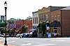 | December 27, 1996 (#96001525) | Roughly bounded by Sacred Heart College campus, RR line, N. and S. Main, Glenway, Bryant Sts., Keener Blvd., Central Ave 35°14′33″N 81°02′22″W / 35.2425°N 81.039444°W / 35.2425; -81.039444 (Belmont Historic District) | Belmont | |
| 5 | Belmont Hosiery Mill | Upload image | September 16, 2002 (#02000987) | 608 S. Main St. 35°14′15″N 81°02′54″W / 35.2375°N 81.048333°W / 35.2375; -81.048333 (Belmont Hosiery Mill) | Belmont | |
| 6 | Bessemer City Downtown Historic District |  | May 19, 2014 (#14000228) | Roughly bounded by 13th & E. Alabama Sts., E. & W. Virginia, E. Alabama & W. Pennsylvania Aves. 35°17′02″N 81°17′03″W / 35.2838°N 81.2841°W / 35.2838; -81.2841 (Bessemer City Downtown Historic District) | Bessemer City | |
| 7 | Andrew Carpenter House | 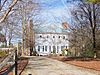 | March 17, 1983 (#83001883) | SR 1820 35°23′19″N 81°03′07″W / 35.388611°N 81.051944°W / 35.388611; -81.051944 (Andrew Carpenter House) | Lucia | |
| 8 | Central School |  | January 9, 2008 (#07001374) | 317 Washington Ave. 35°17′05″N 81°16′36″W / 35.284722°N 81.276667°W / 35.284722; -81.276667 (Central School) | Bessemer City | |
| 9 | Cherryville Downtown Historic District |  | August 17, 2016 (#16000560) | Main, Mountain, 1st, S. Jacob, S. Oak & N. Mulberry Sts. 35°22′44″N 81°22′46″W / 35.378999°N 81.379565°W / 35.378999; -81.379565 (Cherryville Downtown Historic District) | Cherryville | |
| 10 | City Hospital-Gaston Memorial Hospital |  | December 7, 2011 (#11000889) | 401-405 N. Highland St., 810 W. Mauney Ave. 35°16′10″N 81°11′40″W / 35.269444°N 81.194444°W / 35.269444; -81.194444 (City Hospital-Gaston Memorial Hospital) | Gastonia | |
| 11 | Craig Farmstead | Upload image | April 19, 2006 (#06000292) | 118 Craigland Ln. 35°10′50″N 81°06′26″W / 35.180556°N 81.107222°W / 35.180556; -81.107222 (Craig Farmstead) | Gastonia | |
| 12 | Dallas Graded and High School |  | May 2, 2002 (#02000441) | 300 W. Church St. 35°18′52″N 81°10′46″W / 35.314444°N 81.179444°W / 35.314444; -81.179444 (Dallas Graded and High School) | Dallas | |
| 13 | Dallas Historic District | 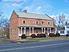 | July 26, 1973 (#73001344) | Bounded by Holland, Main, Gaston and Trade Sts.; also all or portions of Balthis, North Cedar, West Church, North Hoffman, Lewis, West Main, North Maple, McSwain, North and South Oakland, South Pine, Puett, West Trade, West Wilkins and Worth Sts., Brookgreen and Queens Drs. 35°18′58″N 81°10′35″W / 35.316111°N 81.176389°W / 35.316111; -81.176389 (Dallas Historic District) | Dallas | Second set of addresses represent a boundary increase approved April 13, 2022. |
| 14 | Downtown Gastonia Historic District |  | January 6, 2004 (#03001375) | Roughly bounded by Main Ave., Broad St., Second Ave., and Chester St. 35°15′41″N 81°10′56″W / 35.261389°N 81.182222°W / 35.261389; -81.182222 (Downtown Gastonia Historic District) | Gastonia | |
| 15 | Downtown Mount Holly Historic District |  | April 24, 2012 (#12000236) | 100 blocks of N. & S. Main Sts. & W. Central Ave. 35°17′52″N 81°00′58″W / 35.297851°N 81.016093°W / 35.297851; -81.016093 (Downtown Mount Holly Historic District) | Mount Holly | |
| 16 | First National Bank Building | 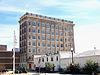 | February 20, 1986 (#86000302) | 168-170 W. Main Ave. 35°15′49″N 81°10′59″W / 35.263611°N 81.183056°W / 35.263611; -81.183056 (First National Bank Building) | Gastonia | |
| 17 | Flint Mill No. 2 - Burlington Industries, Inc. Plant | Upload image | April 19, 2023 (#100008852) | 1910 Hunt Ave. 35°16′32″N 81°09′08″W / 35.2755°N 81.1522°W / 35.2755; -81.1522 (Flint Mill No. 2 - Burlington Industries, Inc. Plant) | Gastonia | |
| 18 | Former U.S. Post Office |  | November 29, 1995 (#95001401) | 115 N. Main St. 35°14′37″N 81°02′18″W / 35.243611°N 81.038333°W / 35.243611; -81.038333 (Former U.S. Post Office) | Belmont | |
| 19 | Gaston County Courthouse |  | May 10, 1979 (#79001708) | N. York and S. South Sts. 35°15′47″N 81°11′04″W / 35.263056°N 81.184444°W / 35.263056; -81.184444 (Gaston County Courthouse) | Gastonia | |
| 20 | Gastonia High School |  | March 17, 1983 (#83001884) | S. York St. 35°15′10″N 81°11′19″W / 35.252778°N 81.188611°W / 35.252778; -81.188611 (Gastonia High School) | Gastonia | |
| 21 | Hoyle House |  | October 21, 1993 (#93001140) | NC 275 south side, 1,400 feet (430 m) southwest of the south fork of the Catawba River 35°19′36″N 81°08′17″W / 35.326667°N 81.138056°W / 35.326667; -81.138056 (Hoyle House) | Dallas | |
| 22 | Eli Hoyle House | 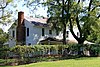 | December 17, 1998 (#98001529) | 1111 Dallas-Stanley Hwy 35°19′37″N 81°08′28″W / 35.3269°N 81.1411°W / 35.3269; -81.1411 (Eli Hoyle House) | Dallas | |
| 23 | David Jenkins House | Upload image | February 17, 1978 (#78001956) | 1017 Church St. 35°15′58″N 81°09′59″W / 35.2661°N 81.1664°W / 35.2661; -81.1664 (David Jenkins House) | Gastonia | Burned July 1987[6] |
| 24 | Loray Mill Historic District | 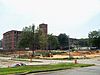 | October 19, 2001 (#01001131) | Roughly bounded by W. Franklin Blvd., S. Vance and S. Trenton Sts., and W. 6th Ave. B; also roughly bounded by S. Vance St., the railroad right-of-way, S. Hill St., and W. Franklin Boulevard 35°15′31″N 81°11′51″W / 35.2586°N 81.1975°W / 35.2586; -81.1975 (Loray Mill Historic District) | Gastonia | Second set of boundaries represents a boundary increase of April 5, 2006 |
| 25 | Mayworth School | 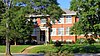 | September 16, 2002 (#02000986) | 236 Eighth Ave. 35°14′26″N 81°04′32″W / 35.2406°N 81.0756°W / 35.2406; -81.0756 (Mayworth School) | Cramerton | |
| 26 | McAdenville Historic District |  | February 5, 2009 (#08001412) | 100-413 Main St., Elm and Poplar Sts., and cross sts. from I-85 to S. Fork of Catawba River 35°15′38″N 81°04′51″W / 35.2606°N 81.0807°W / 35.2606; -81.0807 (McAdenville Historic District) | McAdenville | |
| 27 | Mount Holly Cotton Mill |  | August 1, 1996 (#96000830) | 250 N. Main St. 35°18′02″N 81°00′54″W / 35.3006°N 81.015°W / 35.3006; -81.015 (Mount Holly Cotton Mill) | Mount Holly | |
| 28 | Robinson-Gardner Building | 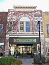 | April 9, 1999 (#99000436) | 173-175 W. Main Ave. 35°15′49″N 81°11′00″W / 35.2636°N 81.1833°W / 35.2636; -81.1833 (Robinson-Gardner Building) | Gastonia | |
| 29 | St. Joseph's Catholic Church | 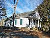 | June 7, 1979 (#79001709) | Off NC 273 35°20′12″N 81°00′01″W / 35.3367°N 81.0003°W / 35.3367; -81.0003 (St. Joseph's Catholic Church) | Mountain Island | |
| 30 | Seaboard Air Line Railway Depot |  | December 20, 2016 (#16000878) | 105 N. Depot St. 35°22′52″N 81°22′29″W / 35.3811°N 81.3746°W / 35.3811; -81.3746 (Seaboard Air Line Railway Depot) | Cherryville | |
| 31 | Stanley Mills | Upload image | December 8, 2022 (#100008466) | 357, 361 North Main, 100 West Parkwood and 111 West Church Sts. 35°21′44″N 81°05′51″W / 35.3622°N 81.0976°W / 35.3622; -81.0976 (Stanley Mills) | Stanley | |
| 32 | Third National Bank Building | 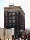 | February 20, 1986 (#86000316) | 195 W. Main Ave. 35°15′49″N 81°11′02″W / 35.2636°N 81.1839°W / 35.2636; -81.1839 (Third National Bank Building) | Gastonia | |
| 33 | Trenton Cotton Mills |  | November 3, 2020 (#100005748) | 612 West Main Ave. 35°15′49″N 81°11′31″W / 35.2636°N 81.1920°W / 35.2636; -81.1920 (Trenton Cotton Mills) | Gastonia | |
| 34 | William J. Wilson House |  | October 14, 1976 (#76001324) | South of Gastonia off SR 1109 35°09′50″N 81°13′13″W / 35.1639°N 81.2203°W / 35.1639; -81.2203 (William J. Wilson House) | Gastonia | |
| 35 | Woodlawn Mill | Upload image | December 18, 2023 (#100009626) | 300 Woodlawn Avenue 35°18′12″N 81°01′07″W / 35.3034°N 81.0186°W / 35.3034; -81.0186 (Woodlawn Mill) | Mount Holly | |
| 36 | York-Chester Historic District | 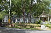 | September 1, 2005 (#05000941) | Bounded by W. Franklin Boulevard, W. 2nd Ave., South St., W. 10th Ave., W. 8th Ave. and S. Clay St. 35°15′18″N 81°11′27″W / 35.255000°N 81.190833°W / 35.255000; -81.190833 (York-Chester Historic District) | Gastonia |
See also
Wikimedia Commons has media related to National Register of Historic Places in Gaston County, North Carolina.
- National Register of Historic Places listings in North Carolina
- List of National Historic Landmarks in North Carolina
References
- ^ The latitude and longitude information provided in this table was derived originally from the National Register Information System, which has been found to be fairly accurate for about 99% of listings. Some locations in this table may have been corrected to current GPS standards.
- ^ National Park Service, United States Department of the Interior, "National Register of Historic Places: Weekly List Actions", retrieved July 12, 2024.
- ^ Numbers represent an alphabetical ordering by significant words. Various colorings, defined here, differentiate National Historic Landmarks and historic districts from other NRHP buildings, structures, sites or objects.
- ^ "National Register Information System". National Register of Historic Places. National Park Service. April 24, 2008.
- ^ The eight-digit number below each date is the number assigned to each location in the National Register Information System database, which can be viewed by clicking the number.
- ^ "North Carolina Listings in the National Register of Historic Places by County". North Carolina State Historic Preservation Office. 22 October 2008. Archived from the original on 30 November 2012. Retrieved 14 July 2009.
- v
- t
- e

by county
- Alamance
- Alexander
- Alleghany
- Anson
- Ashe
- Avery
- Beaufort
- Bertie
- Bladen
- Brunswick
- Buncombe
- Burke
- Cabarrus
- Caldwell
- Camden
- Carteret
- Caswell
- Catawba
- Chatham
- Cherokee
- Chowan
- Clay
- Cleveland
- Columbus
- Craven
- Cumberland
- Currituck
- Dare
- Davidson
- Davie
- Duplin
- Durham
- Edgecombe
- Forsyth
- Franklin
- Gaston
- Gates
- Graham
- Granville
- Greene
- Guilford
- Halifax
- Harnett
- Haywood
- Henderson
- Hertford
- Hoke
- Hyde
- Iredell
- Jackson
- Johnston
- Jones
- Lee
- Lenoir
- Lincoln
- Macon
- Madison
- Martin
- McDowell
- Mecklenburg
- Mitchell
- Montgomery
- Moore
- Nash
- New Hanover
- Northampton
- Onslow
- Orange
- Pamlico
- Pasquotank
- Pender
- Perquimans
- Person
- Pitt
- Polk
- Randolph
- Richmond
- Robeson
- Rockingham
- Rowan
- Rutherford
- Sampson
- Scotland
- Stanly
- Stokes
- Surry
- Swain
- Transylvania
- Tyrrell
- Union
- Vance
- Wake
- Warren
- Washington
- Watauga
- Wayne
- Wilkes
- Wilson
- Yadkin
- Yancey
| |
|---|---|
| Topics | |
| Lists by state |
|
| Lists by insular areas | |
| Lists by associated state | |
| Other areas | |
| Related | |
| |


